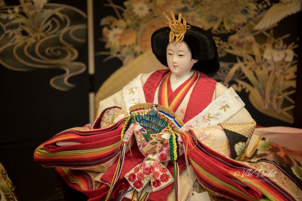
A magical sunset in Aomori

There are days and there are Days. Today was one such day of days or more realistically, evening. We were treated to one of the most memorable sunsets of our lives at Aomori Bay.

It was 4.30 pm by the time we arrived back to Aomori Station from our somewhat educational trip to the ruins of Sannai-Maruyama.

We walked back to the APA Hotel where we were staying for the duration of our trip in Aomori. We got refreshed and then ventured out for a walk along Aomori Bay.

Aomori City

Aomori is the northernmost prefecture of the Honshu, the main island of Japan. Surrounded by the Tsugaru Peninsula in the west, the Shimokita Peninsula in the northeast, and the Natsudomari Peninsula in the east, Aomori Port provides a tranquility similar to the beautiful Osaka Bay. Aomori City is among Japan’s most pleasant towns in the summer. We were just coming form Yamagata and let me tell you, it was hot there. The cool sea breeze blows in from the bay, and the city’s inhabitants are treated to clear blue skies during the days, and striking sunsets in the evenings.

History of Aomori

Aomori first became a port in 1624, when the second Tsugaru lord, Tsugaru Nobuhira, bestowed the name “Aomori” on the small fishing village of Utō. Soon, it was developed as a commercial port. The Tōhoku rail line was opened in 1892, followed by the local Ōu rail line 3 years later and it brought rapid developments to the city. During the Second World War in July 1945, Aomori was heavily bombed during air raids, destroying most of the city. As a result of this destruction, one can find mostly modern buildings around the city. 

Aomori Sightseeing Products Mansion

From the Hotel, we walked down to the Aomori Prefecture Sightseeing Products Mansion. The ASPAM building (Aomori Prefecture Sightseeing Products Mansion) is the most recognizable landmark of Aomori. The triangular building fashioned into an “A” of “Aomori” houses many shops and restaurants selling Aomori’s signature agricultural products and specialty goods. The instantly recognizable, 76m-tall A-shaped tower also houses a tourist information desk, gift shops, and an observation deck which offers spectacular views of the bay.

We walked around the ground floor where many shops were selling traditional art crafts as well as sweets made from apple. Mani purchased an Apple pie box for later. If you’ve ever wanted apple jam, baked apple, apple pastries, apple ice-cream, or indeed anything apple-flavored you can think of, then chances are the ASPAM building is where you’ll find it. Aomori Prefecture is known for its production of apples, so be sure to sample some when you are in the city. I promise you will never forget that taste. Towards the upper floors, the facility has a panorama movie theater, observation deck and restaurants with great view and local cuisine.

The 13th floor observatory has a stunning 360 degree panoramic view of Aomori city, Mt. Hakkōda, and Mutsu Bay. However it was almost closing time and we wanted to take a lazy stroll along the bay.

Blue Ocean Park (Aoi Umi Kōen)

From the ASPAM building, we walked towards the bay through the Blue Ocean Park. This park is considered the best location for gazing at the sea. It has many benches overlooking the bay, so visitors can sit and enjoy the vast ocean while the sea breeze gently blows by.

West Lighthouse at Aomori Bay

We slowly made our way along the central pier. The promenade breakwater was developed and opened to the public in April 2004. This breakwater is 310 meter in length and people can enjoy a relaxing walk by the water.

After a short walk we reached the West Lighthouse. The West Lighthouse is unlike any lighthouse I have seen before. The round, white, broadly conical tower with a lantern has a sharply peaked roof that continues the conical profile of the structure.

Surface of the breakwater is made of wood and natural stones. The benches and observation decks are provided at the central parts of the breakwater. This unusual lighthouse is a landmark in Aomori harbor. There is some confusion over its name. Its Japanese name translates to “breakwater west lighthouse,” however the National Geospatial-Intelligence lists it as “north breakwater, north head.” 

Magical Sunset at Aomori Bay

We were sitting at one of the benches near the lighthouse when the magic started to happen. The sky was in its moods and the sky started changing colors every minute. Far in the horizon, I could make out the silhouette of the container cranes at the port. Nearly 3 million tons of cargo are loaded/unloaded at the Aomori Port every year.

I zoomed in to get a close shot of the sinking sun behind Mt. Maruyakata. Earlier passengers and cargo used to be moved on the Seikan railway ferry. Operation of the Seikan ferry ceased in 1988 when the worlds longest Seikan tunnel with 53.85 km was completed and trains were able to run 1000 meter below the sea bed between Aomori and Hakodate.

Far away in the horizon the sun said a final goodbye to the city as it went down behind Mt. Maruyakata. In a very opposite behavior, the light actually became better after the sun set. The conical shaped lighthouse looked amazing in the orange sky.

It was 7 pm and we bid our final goodbye to the white lighthouse as we head back to the hotel.

Within minutes however the light started to fade away as the Orange sky turned into a many shades of purple. The tripod was a great help in taking the next few shots. 

Walking back, the ASPAM building looked even more beautiful with the lights on, in front of the Bay bridge. As we walked towards the city, we could better see the hanging Bay Bridge. The construction on the impressive bridge in the Port of Aomori was started in 1985 and all lanes were opened for traffic in 1994. The bridge is part of the traffic system essential for goods transportation in Aomori Prefecture and at the same time its impressive design makes it a beauty spot of the city.

I have seen the bridge many times during the day. It is majestic by day and picturesque in the night with its illuminated wires. At night, the lit-up bridge creates a magical atmosphere, which makes it popular among lovers. Click here if you want to see the night shots of the Aomori Bay bridge.

We sat on a bench along the breakwater, mesmerized by the happenings of the last hour or so. With not a soul around us, I could hear the soft relaxing waves and feel the natural tranquility of the surrounding bay.

It was almost 8 pm by the time we reluctantly picked ourselves up from the amazing scene that lay in front of us. We walked down to Shinmachi Street, right beside the ASPAM building, a pedestrian street full of department stores and sushi restaurants. We bought us some packed dinner that we could have back at the hotel. 

This is the city’s main shopping artery and its a different kind of experience wandering at night in these streets. After a short stroll we walked back to the hotel.

It was a good choice to reserve our rooms at Hotel APA, since its walkable distance from the JR station, Wa Rasse Nebuta Museum and also the Aomori bay. The rooms and service are of high standards. If you are visiting Aomori, Hotel APA is a reasonably good place to stay.

For me, an evening stroll on the breakwater promenade was quite a romantic experience. Not only does it gives you an overview of the city, but it also involves a pleasant stroll along the stunning waterfront.  The city has a cool climate year round and enjoys clear transitions between the four seasons. I have spent many evenings in Kobe Harbor admiring the stunning Harborland, but this was magical.

Striking sunsets like these are a regular thing along the enchanting Aomori skyline. Maybe it’s the location with the city hemmed in on three sides by mountains, including, most prominently, the Hakkōda Mountains. I look forward to coming down during fall in the future to see more of its beauty.

I hope you like my post. Thanks for reading. Please do leave me a comment if you liked it or follow my story as I head to Inakadate to witness the amazing Tanbo Rice Art of Aomori.

Ruins of Sannai-Maruyama

Today I visit the ruins of Sannai Maruyama in Aomori. Discovered in 1992, the Sannai Maruyama Archaeological Site is the largest and one of the most complete and best-preserved Jōmon Period (13000-300 BC) village in Japan. 

Morioka to Aomori

I and my wife, Mani were on a short tour of Tohoku region. We were thoroughly refreshed from our previous day at Jōdogahama beach in Iwate. The day was bright and sunny as we checked out of our hotel and walked down to Morioka Station to catch the train to Aomori. As we entered the JR Station, we were quite pleased to see it was still decorated, in lieu of the just-passed Tanabata celebrations.

Tanabata originated from a romantic legend about two lovers that are only able to meet each other once a year. This festival is held across Japan on July 7 or August 7 depending on the region. It’s said that your wishes will come true if you write them down on strips of paper called the tanzaku and hang them on bamboo branches. We left a tanzaku wish note praying for a happy future at one of the booths.

The Shinkansen takes only an hour for the journey from Morioka to Aomori, however, Mani didn’t posses a JR Pass and in order to save some money, we used the limited express train. It was a long 3-hour journey but felt rather shortened by the animated chats about the places we were yet to explore around these parts. 

We reached Shin Aomori at 11 am. The Nebuta festival had just got over in Aomori, the previous day and the station was still adorned with many Nebuta floats all over the place. The Nebuta festival is one of the most popular festivals in Aomori and if you miss it you can always drop down to the Nebuta Museum to witness the amazing floats from the last held festival.

It was almost mid-day and the sun was burning bright, and although Aomori was cooler than Iwate, the strong Sun made it a tad uncomfortable. We left our luggage at one of the station lockers and waited for the bus for Sannai Maruyama site.

The sightseeing bus called Shuttle de Route Bus Nebutan-go arrived in a few minutes. The bus route keeps running in a loop all day, and to reach the Sannai-Maruyama site one has to get down at the Sannai-Maruyama-Iseki-mae bus stop. The ride cost us 310 Yen each.

Jōmon Jiyukan

As we entered the giant hall in Jōmon Jiyukan, the volunteers at the reception helped us out with the information about the heritage site. They provided us with a guided map of the area. Beside the reception, one can also find replicas of dresses from the Jamon period. Visitors are free to try on these Jōmon period clothing. I tried out a fisherman’s dress and I presume, I would have fit right in, into this traditional society 🙂

Once we had gathered all the information, we decided to first take our lunch and then proceed to investigate the huge site. The Gosennen-no Hoshi restaurant inside the campus serves delicious meals using prominent Jōmon ingredients. One can find a variety of set menus made of fish, vegetables and nuts that people during the Jōmon period used to consume.

I am generally a bit circumspect to try new food, but I decided to give it a try anyway. I ordered the “Shiokatsukune Udon.” The dish basically comprised of soft “Chicken meatballs” with bonitos (fish) and kelp soup. I did end up enjoying it and as I write this journal I can feel myself salivating just thinking about it. After the fulfilling meal at the Gosennen-no Hoshi restaurant, we slowly walked down to the Sanmaru Museum.

Sanmaru Museum

The Sanmaru museum exhibits objects excavated from the excavation site and lists many facts about the people who lived during the Jōmon Period. The Jōmon period encompasses a large expanse of time, constituting Japan’s Neolithic period and the museum exhibits approximately 1,700 artifacts excavated from the Sannai-Maruyama site. 

A dimly lit path led us towards a life-sized figure of a young boy with his Inu (dog), pointing us towards the glass encased cases of historical findings from the Jōmon period.

Jōmon no Kokoro

The first section of the Sanmaru Museum is called the Jōmon no Kokoro (heart of the Jōmon Period). This area displays various excavated items including a large number of pottery, stone artifacts, personal ornaments, clay figures, earthenware, wooden utensils, bone tools and small knitted baskets called “Jōmon pochette” from the Jōmon period.

Shown below is one of the stone tools from the site. This grinding stone was particularly used as a food processing tool. Nuts, such as chestnuts, walnuts, and Japanese horse chestnuts were an important source of food for the people at the time. These were used to crush these hard nuts. 

Below you can see some stone spearheads used by the hunters during that period. These hunting tools are characterized by a carefully formed leaf shape and evenly beveled edges that required great skill and patience to create. These tools were created by a process called knapping, where one stone is used to strike another to create a desired shape. If you are a student of history, you will notice that these stone tools, which were somewhat roughly created in the Paleolithic era, were by the Jōmon period meticulously chipped and smoothly polished. 

We moved forward to a large board-shaped clay figurine on display. The Sannai Maruyama village site turned up a huge number of human shaped figurines. From middle to late Jōmon periods, the Jōmon people made large numbers of human figures from clay. However these Jōmon figurines do not look like real people. They have distorted forms with large faces, small arms and hands. Some of the figurines look like humans wearing goggles. This is not new for many cultures who have depicted humans in exaggerated shapes like the Egyptians, but it does make one think if the Jōmon actually had some kind of extra-terrestrial contact.

The pottery vessels crafted in ancient Japan during the Jōmon period are generally accepted to be the oldest pottery in Japan and also among the oldest in the world. The word Jômon literally means “straw-rope pattern,” and it typically describes the style of pottery of the earliest Japanese period. The Jōmon period was named after this style of pottery.

All Jōmon pots were made by hand, without the aid of a wheel. As in all other Neolithic cultures, generally women created these early potteries. Clay was mixed with a variety of adhesive materials, including mica, lead, fibers, and crushed shells. After the vessel was formed, tools were employed to smooth both the outer and interior surfaces. When completely dry, these were baked in an outdoor bonfire.

Pottery found at this site is called Ento (cylindrical) style pottery. A typical Ento style pottery is characterized by an elongated bucket shape with a wide opening and is decorated with cord marks.

Below you can see different sized needles created from bones. In those times, animal bones were used to create harpoon heads, fish hooks, needles and even hairpins. Their varying length, thickness and the eye indicate that the Jōmon people developed them for specialized purposes. Most of the bone needles shown here are made of mammal ribs.

The image below is a cross-section of a mound. Many ritual associated implements were found from these mounds, suggesting the significance of these mounds as a ground for ceremonial activities

Most artifacts used in daily life such as pottery were made at the site using locally available materials. Ornaments include pendants and earrings made of clay, stone, and animal bones.  However certain items came from far away. Jade was favored by the Jōmon people and especially valued in north Honshu where Sannai Maruyama is located. In addition to complete artifacts such as large beads, raw stones have also been discovered here. 

If you want a guided explanation while looking at the exhibits, a volunteer from the Sannai-Maruyama volunteers will gladly guide you round the exhibits.

The Jōmon people of Sannai Maruyama

As we moved further, we were in the Jōmon-jin no Kurashi wo Himotoku (Lifestyle of the Jōmon Period people) section. Here life-sized figurines are used to reproduce the Jōmon daily life, based on excavated objects. The people in the early Jōmon period frequently traveled from one place to the next while engaged in camping and nomadic life. The Jōmon people primarily belonged to a hunter-gatherer culture. 

Over time the sedentary settlements appeared and certain communities engaged in cultivating plants. They gradually moved to a semi-sedentary lifestyle and descended from a mixture of the ancient hunter-gatherer Jōmon and the Yayoi rice agriculturalists. Their features can also be seen in the Ainu and Ryukyuan people. In fact, the Ainu have often been considered to be descendants resulting from a mix of the cultures of the Jōmon people and the Okhotsk. I have written a detailed report on the history of Ainu people.

Below you can see a typical Jōmon family gathering. The historical Ainu culture originated in a merger of the Okhotsk culture with the Satsumon, one of the ancient archaeological cultures that are considered to have derived from the Jōmon period cultures of the Japanese Archipelago. The origin myths of Japanese civilization extend back to periods now regarded as part of the Jōmon period, though they show little or no relation to what we know archaeologically of Jōmon culture, one of the reasons why the Japanese deny Ainu as the aborigines.

After about an hour of adoring the prehistoric artifacts, we moved on towards the excavation site. The Jiyu tunnel led us into the the largest ruins of a traditional village, dating from 4,000 to 5,500 years ago. Stepping into this region is like taking a step back in time.

A brief history of Jōmon People of Sannai-Maruyama

The Jōmon period experienced a large-scale climate change since it extended for a long period of 10,000 years. The Sannai-Maruyama Ruins are the largest ruins of a Jōmon-period (about 10,500-300 BC) village in Japan, and are estimated to date from 4,000 to 5,500 years ago. The Japanese archipelago is extremely elongated from north to south and its topography varies considerably; therefore, regional differences in the climate and vegetation were large during the Jōmon period as is today. As a result, the cultural style of the Jomon period is not uniform both historically and regionally and it came to take many different forms.

There have been previous excavations around the Sannai-Maruyama site between 1953 to 1967. These excavations involved teams from Keio University and the Board of Education of Aomori City. In 1976 and 1987, the Board of Education of Aomori Prefecture and Aomori City also conducted further excavations on the southern part of the site.

However, the major breakthrough for the site came in 1992 while excavating during a pre-construction phase for a baseball stadium. This excavation uncovered how large Sannai Maruyama was as well as a large amount of artifacts. 

After the excavation and study of the site, the village was reburied with earth and a number of reconstructed pit dwellings, long houses and a large tower were built on top. Visitors can enter the reconstructions, some of which are quite large, as well as see a few of the original excavation sites around the grounds.

A large number of pot shards and stone implements, clay figurines, jade beads, etc. were disposed together with the soil and formed a mound for over 1000 years. You can see its cross-section here. X-ray analysis shows that the jade excavated at ‘Sannai-Maruyama Site’ in Aomori Prefecture is from Itoigawa and therefore, it is assumed that the Jōmon people also traded among themselves over the wide area.

These findings demonstrate a change in the structure of the community, architecture, and organizational behaviors of these people. Because of the extensive information and importance, this site was designated as a Special National Historical Site of Japan in 2000.

Sannai Maruyama

Sannai Maruyama was first settled around 3900 BCE. At that time it was inhabited by hunters and gatherers only. Over this period of time, the site changed from a seasonal camp, to the home of a more mobile society, and finally to a settled village. Evidence of this sedentary lifestyle can be found in the the changes in their storage facilities.

Pit Dwellings

The earliest pit dwellings at Sannai Maruyama were during the Early Jōmon period, built between 5900 and 5400 years ago. At that time, Sannai was comparatively small and simple, a collection of pit dwellings. The first settlers on the site lived in pit houses. These dwellings typically were about 10 feet in diameter. The floor was dug below the ground level. A hearth was located in its center. At least 550 pit-dwellings have been discovered so far and 15 have been reconstructed. Some of the pit houses seen at Sannai Maruyama were simple thatched-roof semi-subterranean houses, like this reconstruction. To make this bark-thatched pit dwelling, a pit was excavated into the ground and bark or wood branches were assembled over the top forming a cone-like structure.

Over time the thatched pit dwelling was replaced with a sturdier structure as shown below. Like the thatched huts, the floor of a pit dwelling was dug into the ground. Supporting posts were placed at the corners and the walls and roof were built and roofed with thatch. The average size of these pit dwelling is between three and four meters in diameter.

Store Houses

Initially they used to store food in underground pits, which allowed them to hide it when they left the site since the occupants were not yet living a sedentary lifestyle.  With time, the storage features changed from these underground pits to elevated granaries around 2900 BC. These buildings were built higher than the ground level and were specifically used as storage facilities.

Long House

As the community became sedentary, long houses began showing up around this time. Long houses were large, oval-shaped structures. The longest one found at the site was 32 meters (105 feet) long. Scholars believe long houses were used for meeting places, workshops, or living space. Pit houses were still being inhabited for individual dwelling  at the same time that long houses started to come up on the landscape.

Till now eleven long houses have been excavated at Sannai Maruyama. They were large, oval-shaped semi-subterranean pit dwellings. The reconstruction  shown below is the longest, measuring 32 meters in length. This huge structure displays a coordinated labor force that would have required cooperation of several people to make. This displays the gradual shift from an individual to a social community in this time period.

Watchtower

With a stable living style, also, there appeared one of Sannai Maruyama’s most famous structures, the large six-pillared building, was built around 2,600 BC.  This structure consisted of six large pillars that are believed to have held up platforms. Each one of these pillars was around 1 meter in diameter and was placed exactly 14 ft apart.  This large post like platform was certainly used as a watchtower. 

Burial Pits

Burials at Sannai Maruyama took three forms: jar burials, pit burials, and stone circle burials. Large jars have been discovered near the pit dwelling clusters. These are assumed to be burials, although human bones have not been preserved within them, on the basis of similar burials found in later Jōmon sites such as Yoshinogari. Jar burials have been dated to the Middle Jōmon period, from 5400-4300 years ago. The second form of burial was of adults aligned in rows along the sides of long roadways extending from the center of the settlement towards the outside. Finally as shown below, stone circle arrangements have also been found at Sannai Maruyama, which included adult burials. 

The settlement of Sannai Maruyama ended around 2300 BC.

By now we were extremely dehydrated. The harsh sun had taken its toll and we dragged ourselves to the safety of the Jōmon Jiyukan.

The vending machine at that moment was “gold” for us, as we gulped on the chilled sugary drinks.

The Sannai Maruyama site was designated as a special historical site by the Japanese government in November 2000. Today the public can visit this site and explore its many reconstructions. The site also features a Theater, a workshop and a gift shop. If you are in love with history do not miss this site. Even though at present, most of the excavated items have been reburied for preservation, the excavation sites and artifacts on display will giving you a feel of life in those ancient times.

Thanks for reading. Please leave me a comment if you liked the post or follow my story as we go for a stroll along the lovely Aomori Bay to witness a most alluring sunset.

Open Hours:

9:00 a.m. – 5:00 p.m.

Closed days:

December 30 – January 1
The center is also closed on the fourth Monday of each month. If that day is a holiday, the center will be closed the next day

Admission Fees:

410 Yen

Are baggage lockers available at the site?

Lockers are available for free. You need a 100 yen coin to lock them, but it will be returned when you retrieve your belongings.

Are all objects exhibited in the museum excavated in the Sannai-Maruyama site?

Yes. Sanmaru Museum exhibits approximately 1,700 artifacts excavated from this very this site.

Are there any restaurants at the site?

Yes, you can find a fine restaurant on the premises named Gosennen-no Hoshi, which offers specialty food prepared with Jōmon period recipes and also a kiosk called Hokusaikan.

Do you sell any books about the site?

Yes, many informative books are available at the museum shop as well as the kiosk.

The pure Jodogahama Beach

Today we ride to the scenic Jodogahama Beach. Jodogahama Beach, or “Paradise Beach,” with its series of rock formations is one of the most popular places of scenic beauty along the Rikuchu Coast in the Tohoku region of northern Japan.

Morioka to Jodogahama Beach

Sun was already beating down on us as we walked down to the Morioka Station from our hotel. Summer has been strangely hotter this year.

While much of Japan is easily accessible by train, there are a few areas like Miyoka, that take a bit more effort to reach. This area was greatly effected by the big Tsunami of 2011 and rail services in the area have been greatly affected.

The JR Yamada Line connects Miyako and Morioka, but train service has not resumed on this segment of the line since 2011. Thankfully the roads and tourist facilities in the area have been restored, and while some diversions are in place, the area is now easily accessible via the Iwate Kenpoku Bus.

At Morioka station, the tourist information volunteers happily pointed us towards the Bus ticket counter. 

I was carrying my JR Rail Pass and they didn’t charge me for the round trip bus ride. For Mani, it cost her ¥2000. The #106 Bus run by Iwate Kenpoku is scheduled at regular intervals of an hour and the easiest way to travel to Miyako, unless you have your own car, of-course. The bus stops near the East Exit at stop #7.  We left for Morioka at 11.40 am. The bus was mostly occupied by local residents traveling to Miyako. 

Sanriku Fukko National Park

During most of my travels, I have been treated to a Japanese landscape, adorned with wide areas of paddy fields. However, the Iwate Kenpoku bus travels through the dense forest of Sanriku Fukko National Park. Once past the outskirts of the town, the road leading to Miyako is bounded on either side by woodlands, rich in an endless variety of foliage.

The Sanriku Fukko National Park incorporates two former parks: Rikuchu Kaigan National Park and the Minami Sanriku Kinkasan Quasi-National Park. On the way the bus stops at Yoho for a 10 minutes break. Passengers can get down to stretch their legs or if they want, obtain some snacks or drinks from the store.

The lovely road kept on going and we finally reached Miyako at 1.55 pm.

Miyako City

From Miyako, we needed to take another bus for a short 20 minute ride to the beach. From stop #3 buses leave hourly for the Jodogahama beach and get there in about 20 minutes. While waiting for the bus, I wandered around to have a look at Miyako Station.

The station was mostly deserted since tourists stick to the bus service.

Mani went ahead to the information booth at the station and obtained the bus timetables for our return journey.

Miyako is a small city of approximately 60,000 people. I would say the only reason I was here was to experience Jodogahama beach. The area of present-day Miyako was part of ancient Mutsu Province, and has been settled since at least the Jomon period. On March 11, 2011, Miyako was devastated by a tsunami caused by the 2011 Tohoku earthquake. During the tsunami, waves reached at least 37.9 metres above sea level, almost equaling the record of 38.2 metres created during the 1896 Sanriku earthquake tsunami. It left behind a huge devastation, the city is still recovering from.

The afternoon was getting hotter by the minute and we were thoroughly relieved to see the bus arrive that would takes us to the beach.

The bus dropped us and our fellow passengers at the parking lot of the Jodogahama Visitor center. Below the parking lot we followed the road directly to the Jodogahama Beach. A rest house is located nearby where you can use the toilet or buy food and drinks.

Alas it was a Sunday and the beach was full of sun-bathing tourists. Walking along the pebbled beach we tried but failed to find a decent spot to rest for a bit. 

Jodogahama Beach is Sanriku Fukko National Park’s hallmark spot, thought to have been formed around 52 million years ago in the Paleogene period. These white volcanic rocks that from the bay cut it off from the open sea and tame the waves that hit the shore.

These groups of Paleogene period volcanic rock formations have been weathered by wind and rains into fantastic shapes. Evergreens like the Nanbu red pine, which is a symbol of the prefecture, grow atop these rocks, and the contrast with the white stone conjures up the beauty of a traditional Japanese garden.

Jodo Sect of Buddhism

Now Jodogahama means “Pure Land”, why it was named so is still a mystery for me. One of my Japanese friends tell me – “Jodo” means a place where people go to die. After some researching I found an article about the Jodo sect of Buddhism.

Founded by Honen(1133-1226), the Jodo(Pure Land) sect is based on the worship of Amida, the merciful Buddha of the pure land. The focus of this sect is to show the common folks how to be reborn into Amida’s paradise.

The name Jodogahama is said to derive from a seventh generation Buddhist priest of the Miyako-san Joanji Temple in the Tenna era (from 1681 to 1683) by the name of Reikyo, who, while admiring the sight before his eyes described it as “just like Amida paradise.”  Over the years many have come to consider this vivid contrast of the sharp, white rocks, green pines, and deep blue sea to a Pure Land or Paradise.

Jodogahama Beach

We loitered around the Beach house area for a few minutes but then decided to walk towards a more quieter place.

The waters are a clear emerald blue and the white and vibrant, jagged rocks pierce the calm sea.

The Black-tailed gulls very have a nice time in the shadow areas.

We got into the water to enjoy the cool sparkling water. This beach is perfect for swimming as the sea is calm and the waters warm. Although you might feel the pebbles hurting your foot a bit.

Once the sun mellowed down, we walked along the beach. In many places the limestone rocks can be seen jutting out, creating magnificent shapes.

After walking for a bit we reached a tunnel.

The tunnel led us to Jodogahama Marine House where you can take a small fishing boat to see Blue Cave. So if you aren’t satisfied by just sitting on the beach and soaking in the sights then you can also opt for the Sappa boat cruise. This cruise goes inside Hachinoheana, the Blue Cave. Inside the cave is a blow-hole, which is said to bring good luck. The waters within the cave change colour depending on the season, so when you visit you may be treated to some stunning water. However we were late and the cruise had shut down for the day.

A bit further we found ourselves at the Miyako Jodogahama Boat Cruise pier. From here you can catch the 40-minute tour on the Rikuchu-maru Tour Boat will take you around the islands of Jodogahama.

Tategasaki Tower

We were finally back at the starting point of the trail near the visitors center. The bus was still some time away so I half-sprinted to one of the popular viewpoints at the beach.

From above one can view a wide area of the bay.

Jodogahama to Morioka

The bus took its sweet time coming. The parking lot has a cozy sitting area, so we rested there as we waited for the bus to come along.

A small queue had formed and we also joined it. The bus eventually came and took us back to Miyako station.

At Miyako, the bus that would take up back to Morioka was scheduled for 5.45pm. We still had some time on our hands and we were famished. Down the road we found a store and picked up some food for the way.

We sat in front of the JTB Travel Agency, from where the bus to Morioka was scheduled to pick us up. The bus picked us up at 5.45 and we were finally headed back to Morioka.

Surrounded by deep blue-green waters, Jodogahama Beach is a sheltered by a picturesque line of craggy, white rocks that mean it’s calm shallows are great place to swim in warmer months. It is indeed a great beach for swimming, with clean water and gentle waves. Make sure you walk around the cove, and view the rocky spine from a number of different angles, and there are many walking trails that meander around the area which lead to view points.

Pines cover the surrounding bluffs and crabs and small fish mingle in the the rock pools completing this beautiful scene, making this area worthy of the title “Pure Land” bestowed upon it by the Buddhist Monk Reikyo who felt he had reached paradise on earth when he visited. If you want a little bit of paradise whilst in Japan then Jodogahama beach is the place for you.

We reached Morioka Station by 8 pm. But it still wasn’t the end of day for us 🙂

Thanks for reading. Please leave me a comment if you liked the post or follow my story as we explore the Jomon period ruins of Sannai-Maruyama.

The islands of Matsushima

Designated as one of the Nihon Sankei – the three most scenic views in Japan, alongside Miyajima & Amanohashidate, Matshushima is dotted by as many as 260 islands scattered throughout the picturesque Bay. Today we take a cruise through these pine-covered islands that have left poets smitten across the ages.

We were in Sendai. We spent the early part of the day roaming the streets among the Tanabata celebrating crowds. After an early lunch we rode the local Ishinomaki local from JR Sendai Station to Matsushima-Kaigan Station. Matsushima Bay area is at a walk-able distance from here.

Matsushima Bay Cruise

After reaching Matsushima Bay, we walked straight to the admission counter for the cruise rides. Cruises depart from the boat pier next to the admission booth. The view from Matsushima Pier is itself lovely, but we wanted to get on the boat cruise to see the beautiful islands at close quarters.

There are two options for the cruise, you can either choose the round-trip cruise that comes back to the starting point or get down at Shiogama Pier midway. We choose to go for the round trip ticket, which cost us ¥1500 per person.

We were scheduled for the 4 pm cruise. We had some time on our hands before our turn came along, so we took a short walk around the area. Along the bay, the first thing that catches your eye is the long red Fukuurabashi bridge.

Some boats were leaving with tourists as we wandered along the edge of the shore. It was a hot day combined with a lot of surrounding haze over the bay. On the eastern side you could still see lovely blue skies but the western skies were quite bland and white with the Sun trying to pierce through the haze.

Godai-do

Just a few paces ahead lay a small island connected by a red bridge. On the island, overlooking Matsushima Bay, you can find the Godai-do, a must-see symbol of Matsushima.

Originally known as Bishamon-do, it was founded in 807 CE, during the early Heian period by the shogun Sakanoue no Tamuramaro. However it shot to fame only after 828 CE when the revered priest Ennin, installed images of the Five Deva Kings within the Bishamon-do. From that time it came to be known as Godai-do, named after the five Buddhas of wisdom, housed within, and displayed to the public during a special ceremony only once every 33 years. It was last opened in 2006, so we have to wait another 23 years to view the statues.

The bridge has spaces between the planks. It is said that if you trip between these planks, you are not yet ready to reach the temple.

The Matsushima bay area has seen many natural disasters. The original building was destroyed in one of these unfortunate incidents. The building we see today was reconstructed by Date Masamune in 1604 CE.

This temple is the oldest Momoyama-style architecture in the Tohoku region and has been designated as an important cultural asset. The ceiling within this hall is said to be decorated with the twelve animals of the Chinese zodiac. 

Surrounding the Godai-do, numerous pine trees hang out towards the outer edge of the island. The name of the bay Matsushima – matsu means pine and shima means island, is a clear giveaway why it was named so.

Once it was time for our cruise we made our way back to the pier.

The cruise boat was just arriving as we reached the dock. There are eight cruises per day (seven during the winter months) from 9:00 am to 4:00 pm, sailing every day of the year, weather permitting. The Niōmaru has capacity for 300 passengers, while the newer Niōmaru III can carry 400 people at a time.

Once everyone was off, we queued up to board the cruise boat. The boat has two decks and passengers can sit anywhere, the seats don’t have any numbering. We placed our bags on a couple of seats and walked out to the open area at the back of the boat, so we could enjoy a unhindered view of the beautiful archipelago. You can also go up to the more luxurious upper deck by paying extra ¥500.

As the boat left the shore, the sea gulls followed us into the ocean. One can buy food for the seagulls on the boat to feed them.

As the cruise starts, the first island that you see is obviously the lovely Fukuurajima Island on the left. The largest island in the bay functions as a natural garden. The bridge itself is called Fukuurabashi and is open to the public who can walk to the island by paying a small admission fee.

The Niōmaru boat cruise trip is of about 50 minutes and during that time you can enjoy the beautiful scenery of the islands, up close, with the blue sea as well as enjoy the fresh air around the bay.

Each of the island along the route has different shape and they all have different names and meanings. During the trip there was a running commentary for the entirety of the trip, which functioned as a guide as we passed certain important islands.

All explanations on my cruise were given in Japanese and I wasn’t able to figure out much other than the names of some of the islets. Not to forget, we kept running from side to side of the boat, trying to capture all the little islands that kept passing us.

Sightseeing boat announcements are available in both Japanese and English but they are at different times. Make sure you are buying tickets with the correct broadcast language.

These twin islets below are known as Futagojima.

The islands of Matsushima are the result of a geological phenomenon and each of the islets are points where an ancient valley covered by the water has emerged above the sea level caused by tectonic movements. The depth of the sea surrounding the archipelago does not exceed 10 meters at any point.

Over time, erosion has given these islands unusual forms, some of which looked like mushrooms. The favorable natural conditions caused pine trees to cover the archipelago with a mantle of greenery, making it a unique landscape in Japan.

Formation of Matsushima Bay

Matsushima Bay has been traditionally considered as a typical submerged coast, but research suggests that these islets were formed by a coastal mega-landslide in middle Holocene age, around 4000 BC.

A strong earthquake from nearby active fault was the most probable trigger of the landslide. Hills which used to be located around the area of Matsushima Bay, slid southeast parallel to the bedrocks without breaking into small fragments. The sliding surface, almost horizontal with its own topography formed a layer over the bay, resulting in creation of these small land masses all over the area.

The mega-landslide must have entered the sea and generated a maga-tsunami causing major loss of life to the surrounding Jomon population. Evidence from the shell mounds indicate that the early Jomon people in the area had started settling down on inconvenient highlands which were considered safer from landslides and tsunamis.

Unfortunately the tsunamis are still a cause pain today in nearby areas. One of my friends on Instagram, who is currently residing in Tokyo, had told me how many of his relatives and friends were killed in the disasters, while his home in Minamisanriku, Miyagi Prefecture, which had stood for 300 years and spanned 11 generations, was swept away by the tsunami. That’s a deep scar to live with. My prayers are with him and all the innocent souls lost to the tsunami on that unfortunate day.

After a few minutes we were far out in the ocean where you can unravel as to how far the archipelago stretches into the ocean. We passed by one of the most unique looking islands. Named Kanejima or the “Bell Island” it houses four arches of different sizes that go right through it.

Next on our radar was the Niojima. This is one of the most iconic island in the bay. People have given some strangest of descriptions of this island. Let me add another as to me it appeared as a whale blowing its snot.  

We stopped at this point for a few minutes to allow the people on board to enjoy the lovely views of the ocean, after-which the boat turned back on-route to the shore. Longer cruises will get you to further remote areas of Oku-Matsushima.

Summit level of these Matsushima Islands are usually about 50 m high.

Matsuo Basho, one of the most famous of Japanese haiku poet, is said to have been at a loss for words when he first saw the hundreds of pine-clad islets scattered around Matsushima Bay during a 17th-century journey to the Tohoku region.

Heavily romanticized by Japanese travelers, the pine-covered islands, battered by wind and sea form a kind of Zen rock garden in the ocean.

We were back at the pier at around 5 pm. There was still daylight, and we didn’t want to back so soon.

After disembarking from our boat we turned right and walked along the main street which was lined with many interesting looking shops. We walked past the Godai-do, where we had already been earlier in the day and followed a narrow path along the ocean arriving at a tiny building at the mouth of the Fukuura Bridge.

Fukuura Island is one of the few pine covered islands in Matsushima Bay that is accessible to the public. The island is reached via this 252 meter long, red painted bridge.

The building serves to control access to the island and is where you pay the ¥ 200 admission to enter the island. It was 5 pm already and there was no one at the admission booth. We decided against going to the island as it would be dusk soon.

From what I read, there is not much to see on the island besides plants and views of the bay. The island is a natural botanical garden with a network of pleasant walking trails. It takes about one hour to walk all the trails at a leisurely pace. Some nice views of the bay can surely be enjoyed along the way.

We sat on a bench nearby, admiring the scene till the sunset. Once the Sun was gone we made our way back to Matsushima Kaigan Station for the train to Sendai. The train was still some minutes away so we waited at the platform with other visitors.

From Sendai we caught the Tohoku-Hokkaido Shinkansen to Morioka which was our next stop on our tour of the Tohoku region. It takes about 2 hours to reach Morioka from Sendai. It was pretty late into the night as we pulled into Morioka. The station though, was still alive with Tanabata decorations.

We grabbed some dinner from a convenience store nearby and headed to our hotel. The body seeps well after a tiring day, next day was going to be a long day as well as we were planning to go to Jodogahama Beach.

I didn’t have time to cover more of Matsushima. There are many other attractions in the Matsushima Bay area. Some of the popular temples include

  • Zuiganji (the most renowned Zen temple in Tohoku area)
  • Entsuin Temple (mausoleum of Date Mitsumune) and
  • Tenrinin Temple (mausoleum of his daughter, Lady Iroha).

Fukuurajima (one of the islands covered by pines), is also worth a visit but unfortunately I was out of time. The long, red Fukuurabashi Bridge and Godaido Temple are also illuminated at night if you are interested. 

Photographs can never tell the emotions I felt standing on the boat as I sped past these incredible shaped islands. I hope they can inspire some of you to reach out and witness what I have. If you visit Miyagi Prefecture and want to enjoy some fresh air as well as a mesmerizing scenery, then Matsushima Bay is definitely worth a visit!

Thanks for reading. I look forward to your comments and questions. If you are looking to explore more of the Tohoku region, follow my travels as I visit the Jodogahama Beach in the interiors of Morioka.

Matsushima Bay Cruise Timings

9 am to 4 pm

Roundtrip and Matsushima-Shiogama Cruise cost (Updated 2019)

¥1500

Round-trip cruises between Matsushima and Saga Kei cliffs

¥ 2500 (between April and October only) 

A stroll to Jozenji-dori

Jozenji-dori is the soul of Sendai, the city of trees. Zelkova trees line the boulevard on both sides for about 700 meters, running east to west through the heart of the city. We were double lucky to be there at the time of the Tanabata festival when the entire road leading to Jozenji-dori was filled with colorful Tanabata decorations.

Our day starts from the quiet town of Tendo.

We took the train to Yamagata and from there caught the Shinkansen to Sendai.

Sendai Station was adorned with Tanabata decorations.

We were in the city for just a few hours, so we decided to take a walk to Jizen Dori, one of the popular tourist destinations in the heart of the city. The Sun was quite sharp as we came out of the station.

From the station, we followed the decorations along the streets as we made our way towards Jizen Dori.

There was a never-ending show of tanabata decorations and the streets were crowded as hell.

We kept following the decorated street.

Until we were finally at the popular statue of Jizen Dori

This is an iconic statue of Sendai

After resting for a few moments, we took a bus back to the Sendai Station.

We bid adeu to Sendai, as we left for Matsushima, our next stop in our tour of Tohoku.

Thanks for reading!

On the Urabandai Goshiki-numa Trail

Today we go for a hike along the Goshiki-numa trail in Bandai-Asahi National Park, that runs along five gorgeous ponds. These ponds were created by the eruption of Mt. Bandai in 1888, after which the volcanic minerals dissolved in the water, imparting each pond with its own shade of color ranging from green to whitish blue.

We were staying in Aizu-Wakamatsu and spent the previous evening enjoying a most lovely evening at Tsuruga Castle grounds. We rose up early to catch the local train on the Ban-Etsusai Line and reached Inawashiro Station at around 9 am. It takes about half an hour to reach Inawashiro from Aizu-Wakamatsu and the ride is free for Japan Rail Pass holders.

Goshiki-numa

Goshiki-numa (五色沼), is a cluster of five volcanic lakes and ponds situated at the foot of Mount Bandai in the center of the lake district of Bandai-kōgen, in Fukushima.

The prefecture of Fukushima is blessed with one of the most lovely countryside and the Bandai-Asahi National Park is the most beautiful feather in its cap. Visitors to the park can marvel at Mt. Dewa-Sanzan, which is famous as a site for mountain worship, gaze upon the peaks of Asahi, Iide and Mt. Bandai, or enjoy the beautiful sights of hills and numerous lakes and marshes from vantage points in the Urabandai area and Lake Inawashiro.

But none is more interesting than the Goshiki-numa Nature trail that walks you along five gorgeous ponds/lakes formed by volcanic activities in the region. These ponds were formed when the summit of Mount Bandai on the northern side collapsed due to a steam explosion. The subsequent rock avalanche blocked the river Aga, which led to the formation of numerous water bodies in this area. Goshiki-numa is just one of many such groups of lakes & ponds formed during the eruption.

From the Inawashiro station we took the Bandai Toto bus to the Goshikinuma-iriguchi bus stop. The bus takes about 30 minutes and will drop you right in front of the Urabandai Tourist Information center, which lies at the start of the Goshiki-numa Trail. The bus ride costs ¥720 (one way) and is not covered by the Japan Rail Pass.

The Urabandai Tourist Information center is large and well-equipped, and provides information not only about touring the area, but on the geography, wildlife and history of the area itself in various exhibits, including video. Urabandai (裏磐梯) literally means “behind Bandai” and we were told that at certain viewpoints we could see the peak clearly along with the ponds.

Sitting deep into the forest, this center provides luggage counters, maps and pamphlets in English as well as any other information you may need for the Nature walk. Toilets are also available at the center.

We dropped off our heavy suitcase at the center and after collecting the map of the Goshiki-numa area, we started on the walk.

Bishamon-numa

The first pond on the trail is the Bishamon-numa Pond. It was summer and the beautiful Ajisai was blooming. If you love Ajisai flowers, do visit Hase-dera in Nara for a brilliant show of blooms during summer.

A little up ahead we found ourselves in front of a most beautiful teal colored pond, though in my opinion it looks more like a lake.

The colors of these lakes mysteriously fluctuate throughout the year with the weather.

On the Bishamon-numa, row boats are available for hire. People were enjoying the beautiful weather on boats along the pond.

After admiring the beautiful Bishamon-numa Pond, we moved forward along the trail shown on the map. The trail is clearly marked and it was quite easy to follow the directions.

There are several vantage points around Goshiki-numa where visitors can enjoy breath-taking views of Bishamon-numa Pond. I personally loved this view point below that catches the lovely colors of the pond with Mt. Bandai in the background.

From here the trail moved into a wooded area surrounded by thick foliage. We were followed by other groups of Japanese along the trail. In fact all along the route we kept seeing more and more people, so it seems it is a pretty popular spot during summers.

At certain points the wood becomes so thick, its hard for the sunlight to get through.

If you can get a little close to the pond, you can find colorful Koi swimming in the waters. Be sure to keep an eye out for the rare one with heart-shaped spots on its side which is believed to bring good luck!

After a while as we hiked up, the forest opened into a clearing. From here you can see a different angle of the Bishamon-numa Pond.

We gradually moved on along the stone path. It was also getting hotter as we were now into the afternoon.

Aka-numa

The next pond on our trail was the Aka-numa Pond (Red Pond) . Although the name highlights its reddish-ness, its color is much more of a muddy green. Due to the high iron content of water seeping into the roots of the reeds, it imparts a reddish tint to the edges of the pond.

Along the trail you can find different variety of flowers blooming near the pond.

In the below close up photo, you can see clearly the reddish reeds along the edge of the pond. After taking a few pictures of the Aka-numa Pond, we moved ahead.

We continued on our hike through the forest. Along the hike I noticed many carrying small bells, making a tinkering noise. I later came to know that those bells were to keep bears away. Yes! Bears!! I don’t feel so safe now :O

The area is supposedly famous for Asiatic black bears but we were luckily, we didn’t get to meet any of them today. Many hikers swear by bear bells as a good way to keep from accidentally running into them but I have read of several accidents involving bears in the Tohoku region where the bells were of little help.

About midway through the hike, we could hear the sounds of flowing water. After looking for sometime, we noticed this small stream of water flowing into a nearby pond.

Benten-numa

When we came out again in a clearing, a light aqua colored pond lay in front of us. It is called the Benten-numa (Benten is the Japanese goddess of the arts and wisdom. It is undoubtedly the second largest of the five ponds.

The trail goes in a semi-circular path around the pond with several viewpoints to capture the breadth-taking colors of the pond.

Benten-numa, too, is surrounded by quite thick foliage so is a little difficult to get a good look out over, but, like Bishamon, features a backdrop of Urabandai mountains.

We were soon back into the woods.

Ruri-numa Pond

We were soon at the Ruri-numa Pond (Lake Lapis Lazuli) . The Ruri-numa is named so for the deep, rich blue of its waters, which are probably the clearest of any of the Goshikinuma ponds.

It was here that I dropped my Nikon 810 for the first time. Yes, while entering this area, I slipped over the dusty rubble and lost my footing. It was a good thing that my Black Rapid camera strap kept the camera close to my body. Nothing happened to the camera except for some scratches on the bottom.

Fortunately the fall didn’t do much damage to this tank of a camera and I was able to keep clicking more pictures of this gorgeous lapis lazuli colored pond.

This was not as big as the other ponds

Yanagi-numa

From here the Yanagi-numa is not very far off. Yanagi-numa (“Willow Pond”) lacks the sludge-filled bottom of the other ponds, therefore it lacks the “magic” hues and tints. However, the water is very clear and faithfully reflects its surroundings, making for another special kind of beauty.

The water in this pond was of a natural color.

So there you have it – a pictorial tour of the Goshikinuma Nature Trail. From this last pond on the trail you can choose to go ahead where you can find a bus stop to take you back. We however had to go back as we had left our luggage at the Tourist office. so we went back quickly along the same trail.

Most tourists had left boating by the time we arrived back at the starting point of the trail – Bishamon-numa Pond

The bus arrived on time and we were back to the Inawashiro Station.

We were on our way to Tendo, we we would stay for a night before advancing to the next stop on our Tohoku tour – Sendai. We had a lovely day at Goshikinuma Nature Trail. The name, Goshikinuma, as written in Japanese (五色沼 or five color ponds), is rather a misnomer. The area consists of many more than five ponds, and is also famous for displaying a much larger spectrum of spectacular colors.

The ponds have earned the name “Mystic Marsh” due to this characteristic. The sightseeing trail around the ponds is 3.6 km long and takes approximately 70 minutes to walk. Urabandai is also popular for autumn color viewing. Due to the wide range of elevations, colors can usually be seen somewhere during the entire month of October.

Thanks for reading! I look forward to your comments and questions. If you are looking to explore more of the Tohoku region, follow my story as I make a stop-over at Sendai and then go for a cruise over the beautiful Matsushima Bay.

The Tsuruga Castle

We take a walk to the Tsuruga Castle in Aizu Wakamatsu, a city where the influences of samurai remain strong even today. The five storied impregnable fortress and castle tower that stands today is a replica reconstructed in 1965, based on photographs and historical documents of the preceding Kurokawa Castle, built in 1384.

Catching the train to Aizu-wakamatsu

Statue of young Byakkutai warriors in front of Aizu-wakamatsu station

Akabeko, the legendary cow from the Aizu region of Japan

After dropping our luggage at the Hotel, we waled back to the station to catch the bus to Tsuruga Castle.

The bus drops you off at the Tsuruga Castle Bus Stop – Tsurugajo Kitaguchi

After walking for a few minutes we found ourselves in front of the castle walls.

The moat surrounding the castle grounds is lovely to walk around.

Chuukonhi Liberty Monument

Bell Tower on Tsuruga Castle Grounds

Tsuruga Castle Park

Tsuruga Castle

Close-up of the Tsuruga castle keep.

Tsuruga Castle Park

As evening set it, the sky turned magical

Once it was dark, the castle was flooded with colorful lights.

Walking back to the hotel

Thanks for reading!

The mysteries of Okinawa Churaumi Aquarium

We took a bus all the way from Naha to Okinawa Churaumi Aquarium. The aquarium goes up to four floors, with tanks containing deep-sea creatures, coral, and tropical fish. The main Kuroshio Sea Tank holds an enormous 7,500 cubic meters of water, stretching from the first floor all the way to the second floor of the aquarium.

Dawn in Naha

Umisora Park

Waiting at Bus Stop

Getting down at Ocean Expo Park

Ocean Expo Park

Sishi Lion

Walk to Chiraumi Aquarium

Entrance to Chiraumi Aquarium

Aquarium entrance

The Sea of Tropical Fish

Jelly Fish

Moonlight Jellyfish

The Kuroshio Sea Tank

Scalloped hammerhead

Zebra shark

Giant trevally

Aqua Room

Ocean Expo Park

American manatee

Walking to Emerald beach

Rocks along the coast

Sitting area on Churaumi Aquarium Grounds

Hotel Orion Motobu

Emerald beach

Catching the bus back to Naha

Getting down near Naha city hall

Walking along Onaribashi-dori in Naha

Snack time at Tendon Hasegawa

Walking back to Naha Beach Side Hotel

Thanks for reading!

The radiant Shuri Castle

31 October 2019 Update. It is a sad sad day as I see helicopters capturing the video footage of the Shuri Castle in flames. A massive fire broke out and burned down the Seiden, the main hall, and also the Hokuden and Nanden. The fire alarm went off around 2:30 am and by afternoon, the fire had completely gutted six of the castle’s heritage buildings. I feel a heavy burden in my heart as Okinawa’s most iconic heritage site and some of my most memorable moments vanished up in smoke.

This is my story of when I visited the castle in 2016.


Shuri Castle is a Ryukyuan gusuku castle in Shuri district of Okinawa Prefecture in Japan. The castle was built sometime in the 13th century by Shunbajunki, the second king of Chuzan. It served as the center of politics, foreign affairs, and culture of the Ryukyu Kingdom until the archipelago was annexed by the Japanese Meiji government in 1879 CE.

My day began among sunny blue skies in Nara. It was hot, but the strong breeze made it pleasant. I and my wife, Mani, got up early and had a light breakfast. We packed light. The trip to Okinawa was a short one and a single cabin bag was enough for both of us.

Our flight to Okinawa was scheduled for 10.30 am. From Nara, we took the limousine bus to Osaka KIX Airport. From KIX Airport, we caught the flight to the Ryuku kingdom on the southernmost island of Japan.

If you are catching a Peach flight from KIX Airport, you will need to get down at Terminal 2

Peach Airlines is one of the cheapest ways to reach Okinawa from Osaka. I wouldn’t recommend flying economy if you are a large figure. The spacing on the aircraft was quite constrained. Thankfully the discomfort only lasted for a wee bit over 2 hours.

We landed in Okinawa at 12.40 pm to wonderful but hot weather. The airport building is directly connected to the Okinawa Urban Monorail, also known as Yui Rail. The monorail line serves as a useful commute in the busy cities of Naha and Urasoe in Okinawa. If you don’t have anyone to pick you up and you want to save on the cab fare, you can use the monorail, which takes you directly into the city.

Fact: Okinawa is the southernmost island of Japan and Akamine Station and Naha Airport Station, are the southernmost and westernmost active rail stations in Japan.

It was only later while writing the journal that I realized, that at that moment I had inadvertently traveled to the southernmost train station in Japan. For the record, I have already been to the northernmost active station in Japan.

We had to wait for some time before the train arrived. We were heading to Asahibashi Station, where, just a few blocks away, we had booked our stay at the Naha Beachside Hotel.

As the monorail carried us into the city, I kept staring out of the window with the excitement of a schoolboy on a camping trip. I have to admit that Naha is unlike any Japanese city. Not only are the homes designed differently, but the trees and shrubs are also more tropical, like the ones found in my home city of Kolkata.

From Asahibashi Station, it was a long walk to the hotel. We were exhausted by the time we reached the hotel, but we still had some time before we could check-in. So, we just dropped our bags at the hotel reception and walked back to Asahibashi Station. The Sun was extremely strong, but we kept going.

At Asahibashi station we gathered the available information regarding local sightseeing and train timings. Since we were already out, we decided to head out to Shuri Castle. On the way, we grabbed some onigiri from a nearby convenience store.

Trains are at 8-minute intervals and it takes about 17 minutes to get to Shuri Station from Asahibashi. Within a few minutes, the monorail came wooshing along and we were on our way to explore our first heritage site in Okinawa.

The train comprised of two coaches, with a capacity of around 100 people. After getting down at Shuri Station, we were not sure about the directions to the castle so we used our phone navigation to guide us towards the castle grounds.

Shuri Castle is surrounded by a massive park. Within the castle park, there are numerous historical buildings and sites that have been passed down from the bygone era. Usually, one gains access to the castle’s grounds via the Shurei-mon Gate and passes the stone gate – Sonohyan-utaki, before entering the actual fortification walls at the Kankai-mon. However, we wanted to explore a few other structures surrounding the park before entering the castle grounds.

Benzaitendo

The first building we landed at was the Benzaitendo, sitting idly in the middle of a manmade pond called the Enganchi. A masonry bridge, called Tennyo bashi, connects the edge of the pond to the small building. The railings of the stone bridge are beautifully decorated with images of lotuses on either side.

The Enganchi is a man-made pond. It was initially constructed in 1502, to hold the spring water and rainwater that flowed from the top of Shuri Castle. Water that overflowed from this pond was collected at the Ryutan, another pond located adjacent to it.

The Benzaitendo, sitting idly in the middle, with faded, red roof tiles, enshrines the goddess Benzaiten, a deity that watches over people on voyages at sea. But I hear that it was always not so. The history of this pond and the building in the center goes back to the mid-15th century, during the reign of King Sho Toku.

The Sho family ruled the Ryukyu Kingdom from the early 15th century through 1879 when it was annexed by Japan and renamed Okinawa Prefecture

Precious Housatsuzou-kyou (Buddhist scriptures) were presented by the Korean king Sejo of the Joseon Dynasty to the then king of Okinawa, King Sho Toku. Many years after the death of Sho Toku, In 1502, by the order of King Sho Shin, a small building was built over the Enganchi Pond in order to house these scriptures.

The building was destroyed in 1609 during the invasion of Ryukyu by forces of the Japanese feudal domain of Satsuma. When it was later restored in 1629, an image of Benzaiten was enshrined here. The statue was ruined a couple of more times but it was always restored. The last time it was destroyed was during the Battle of Okinawa but again restored in 1968.

After exploring and capturing some the shots of the pond, we moved on towards the back of the castle.

Shuri Castle Grounds

Built inside a sprawling complex, Shuri Castle or Shuri-jo, includes layers of inner and outer walls constructed in different eras. As I mentioned before, Shuri-jo is a Ryukyuan gusuku castle. The “Gusuku” were basically walled compounds created between the 12th to 16th centuries, that evolved into forts and castles of local chieftains. Not all gusuku buildings evolved into castles, some of them were also religious centers used for traditional religious rituals such as nature worship.

Like other gusuku, the Shuri Castle was built using Ryukyuan limestone. The outer walls which were built during the Second Shō Dynasty, dates back to the 15th-century, while the inside walls were commissioned some time in the mid-16th century. Surrounded by these winding stone walls, Shuri-jo is neither an imposing citadel like the Matsumoto Castle nor a fortress-like the Matsue Castle. Locals describe it as a castle designed to welcome people.

Most parts of the castle can be explored free of charge. Only if you want to see the very inner parts of the castle, you’ll have to buy admission tickets, which can be purchased at the Kōfuku-mon.

Kyukei-mon Gate

We entered the castle grounds from the Kyukei-mon Gate at the back. Its foundation was laid sometime in 1477 and it was completed in 1526. Kyukei-mon is also known as Hokori Ujo. While the Kankai-mon was the main gate, Kyukei-mon functioned as a service gate where mainly women passed through. The gate was also used on certain occasions by the King when he visited the temple at the base to offer his prayers or during times he visited Urasoe district in the north

From the Kyukei-mon Gate a cobbled path leads to the Kankai-mon gate. From there a curving path leads to the Zuisen-mon gate.

Zuisen-mon

Two Shishi lions, carved in stone sit on either side of the Zuisen-mon gate. “Zuisen” means “great, auspicious fountain,” and the gate was named after a “dragon head” water conduit called “Ryuhi” in front of the gate. Shishi lions traditionally stand guard outside the gates of Japanese Shinto shrines and Buddhist temples. They are always depicted in pairs, one with mouth open and one with mouth shut.

A few paces up the path leads you to the Houshin-mon Gate.

Houshin-mon Gate

Hoshin-mon Gate means “a gate to respect the gods.” Beyond the Houshin-mon Gate you will find yourself in front of the Una Forecourt with the beautiful Seiden Hall at the end.

Shuri Castle

The date of construction of Shuri Castle is uncertain, but it was clearly in use as a castle during the Sanzan period (1322 – 1429). It is believed that it was probably built during the Gusuku period (1050 -1429), like most other castles of Okinawa. The beginning of the Gusuku period corresponds to that of the Old Ryukyu period of Okinawan historiography, both beginning in 1187 with the semi-legendary ascension of King Shunten. When King Shō Hashi unified the three principalities of Okinawa and established the Ryukyu Kingdom, he used Shuri as a residence. At the same time, Shuri flourished as the capital and continued to do so during the Second Shō Dynasty.

The characteristics of Ryukyuan architecture at Shuri-jo lies in the unique features of Ryukyuan designs arranged with the influences of both the architectural styles of Japan and China. The Seiden is the Honden or the main hall of Shurijo Castle and, unlike Japanese castles with Tenshukaku or castle towers, it shows architectural styles of Chinese imperial structures and strong influences of Japanese architectural features of shrines and temples.

A three-story structure with wide stone steps at the front, and the dragon pillars of Dairyuchu and Shoryuchu which are carved out as columns. At the center of the Seiden’s roof is a design known as Karahafu.

The karahafu is perhaps the most instantly recognizable Japanese architectural feature, yet its origins are not well established in Western literature. Folk etymology suggests that the style was imported from China sometime during the Nara or Heian period. You can clearly see its ominous presence at the entrance to the Todai-ji.

Seiden Hall of Shuri Castle

For 450 years from 1429, it was the royal court and administrative center of the Ryukyu Kingdom. It was the focal point of foreign trade, as well as the political, economic, and cultural heart of the Ryukyu Islands. According to records, the castle burned down several times, and rebuilt each time.

The 15th century was the kingdom’s golden age but after that, it experienced one hardship after another. During the reign of Shō Nei, samurai forces from the Japanese feudal domain of Satsuma seized Shuri in May 1609. The Japanese withdrew soon afterwards, returning Shō Nei to his throne two years later, and the castle and city to the Ryukyuans, though the kingdom was now a vassal state under Satsuma’s suzerainty and would remain so for roughly 250 years.

After taking a breather we walked in to explore the interiors of the castle. In order to enter the Seiden, one enters the buildings on the right hand side of the Una at the one-storied Bandokoro, which houses, just like the connected, two-storied Nanden, a museum documenting the eventful history of the castle and royal dynasties of Okinawa.

The Shuri Castle complex itself can be divided into three main zones, namely a central administrative area (including the Seidan and Ura), an eastern living and ceremonial space (behind the Seidan) called the Ouchibara (literally “inside field”), and a southwestern ceremonial area including the Kyo-no-uchi. The living quarters were occupied by the Ryukyu Kingdom’s ruling family from 1429 to 1879.

The Hokuden also houses two miniatures of the palace’s buildings set for special ceremonies. The seating arrangement will surely remind you of scenes from mythological movies depicting the Forbidden City in Beijing.

The throne in the Karahafu area of Shuri Castle. The first floor of the Seiden was referred to as Shichagui, and this was where the King himself mainly led the ceremonies. The lavish area at the center was called the Usasuka, the royal throne where the King presided for various ceremonies. Through the sliding Shoji screens behind the Usasuka is the Ochokui, a set of stairs used exclusively by the King, and it was from these stairs that the King arrived to the Usasuka from the second floor.

The dragon is a vast imaginary beast that originally symbolized the Chinese emperor. The Ryukyuan king made extensive use of dragon images in imitation of the emperor.

The second floor of the Seiden is called the Ufugui and at the center is where the King’s throne was placed, on a platform similar to that of Shumidan Buddhist altars. Above the throne were a number of framed writings sent by Chinese emperors that read, Chuzan Seido – Ryukyu is to be ruled by the King of Chuzan; Shuzui Kyuyo – Ryukyu is where auspicious markings gather, and Eiso Eizen – rule the Kingdom of Ryukyu found across the seas with eternal happiness. These writings were framed after coated with lacquer in Ryukyu, and displayed in the palace.

The glorious throne we can see today is a reconstruction of the throne used by King Sho Shin, who ruled the island from 1477 to 1526.

There are a total of 33 dragon ornaments inside and outside of the Seiden, including the pair of large dragon pillars standing at both sides of the main entrance.

Here we have the The Royal Crown is also called HIBENKAN or TAMANCHAABUI. Along with a formal costume gifted by the Chinese emperor, it was a formal wear for the king at such nationally significant events as Sappo (enthronement of the king) and the New Year’s celebration.

Black silk crepe was attached to the crown’s surface, and 12 of tape shaped golden threads were sewn on it. 7 kinds of 24 beads – a total of 288 beads – including gold, silver, coral, and crystal were tacked on each golden thread. A dragon, the symbol of the king, was engraved in the golden ornamental hairpin.

In 1879, the kingdom was annexed by the Empire of Japan and the last king, Shō Tai, was compelled to move to Tokyo, and in 1884, he was “elevated” to the rank of marquess in the Japanese aristocracy. The kingdom was turned into Okinawa Prefecture, and its 500 years of history came to an end. Subsequently, the castle was used as a barracks by the Imperial Japanese Army. The Japanese garrison withdrew in 1896, but not before having created a series of tunnels and caverns below it.

In 1908, Shuri City bought the castle from the Japanese government, however, it did not have funding to renovate it. In 1923, thanks to Japanese architect Ito Chuta, Seiden survived demolition after being re-designated a prefectural Shinto shrine known as Okinawa Shrine. In 1925, it was designated as a national treasure.

Ryukyuan elements also dominate. Like other gusuku, the castle was built using Ryukyuan limestone, being surrounded by an outer shell which was built during the Second Shō Dynasty from the second half of the 15th century to the first half of the 16th century. Similarly, Okushoin-en is the only surviving garden in a gusuku in the Ryukyu Islands, which made use of the limestone bedrock and arranged using local cycads.

The large dragon pillars erected on both sides of the stone steps at the center of the Seiden are called Dairyuchu, and these were first created in 1508. Later, they were remade several times as the Seiden saw reconstruction works after fires. The present Dairyuchu were made after 1712, and their shape and size were referenced from damaged remains of the present pillars that managed to survive the ravages of war, and also from records that documented repairs of the Seiden in 1758.

Unlike Japanese castles, Shuri Castle was greatly influenced by Chinese architecture, with functional and decorative elements similar to that seen primarily in the Forbidden City. The gates and various buildings were painted in red with lacquer, walls and eaves colorfully decorated, and roof tiles made of Goryeo and later red Ryukyuan tiles, and the decoration of each part heavily using the king’s dragon.

Shuri Castle operated not only as a base of political and military control, it was also regarded as a central religious sanctuary of the Ryukyuan people. Formerly there were 10 utaki (shrines) within the castle and the large area on the south-western side of the citadel was occupied by a sanctuary called the Kyo-no-uchi.

We take it for granted so naturally that the islands of Okinawa are an integral part of Japan, and yet the fact is it has only been less than 150 years since they became part of the Japanese Empire.

We were both extremely tired from the exhausting walk. As the sun set of the beautiful castle we made our way down. The street lamps were on. I wished I had had some strength to set up the tripod, but I was very tired. The shots thereafter are noisy as they were taken hand-held.

We passed by the Tennyo Bashi which was dimly lit up and looked fantastical in the night.

We took the monorail back to Asahibashi Station. On the way to the hotel, we grabbed some food from a convenience store to eat at the hotel.

It was about 9 pm by the time we reached the Naha Beachside Hotel. We checked in quickly and directly went for a hot tub bath.

Shuri Castle’s history is enmeshed in the imperialist history between the island of Okinawa and Japan, which annexed the Ryukyu Islands into its feudal domain in 1879. Before then, Shuri had been the capital of Okinawa. Now, the city is part of Naha, the new capital of Japan’s Okinawa prefecture.

Thanks for reading! Tomorrow we head out to the Okinawa Churaumi considered one of the biggest aquariums in the world.

Open Timings:

April to June: 8.30 am to 7 pm (last entry: 6.30 pm)
July to September: 8.30 am to 8 pm ( last entry: 7.30 pm)
October to November: 8.30 am to 7 pm (last entry: 6.30 pm)
December to March: 8.30 am to 6 pm (last entry: 5.30 pm)

Admission fees:

Adults: 800 Yen