The Dunes of Tottori

JR Train Station

Bus to Tottori Sand Dunes

Parking lot

Tottori Sand Dunes Entrance

Tottori Sand Dunes

Viki at Tottori Sand Dunes

Mani at Tottori Sand Dunes

Climbing the Horseback Dune

Atop the Horseback Dune

View of the Sea

Western coast

Setting up my tripod

Catching the sunset over Tottori Sand Dunes

Mani at sunset

Twilight

Leaving Tottori Sand Dunes

Waiting for bus

Tottori at night

Thanks for reading!

Eye of Engetsu

This is a three-part story which began at dawn, with me traveling all the way from Nara to Wakayama. In Wakayama, Sandanbaki Cliffs wes the first place I visited. After spending a couple of hours at the cliffs I walked down to the lovely Shirahama beach.

The bright morning had grown into a lovely afternoon. I was in the mood for a long walk, so I left the white sands of Shirahama Beach and started my walk towards Engetsu Island.

Engetsu Island is a small white sandstone island just off Shirahama’s coast in Wakayama Prefecture. From the beach, it took me about 30 minutes on foot to reach the Engetsu viewpoint. Buses are available, but they run at long intervals, so you have to time yourself perfectly or you will end up losing a lot of time waiting.

Engetsu Island

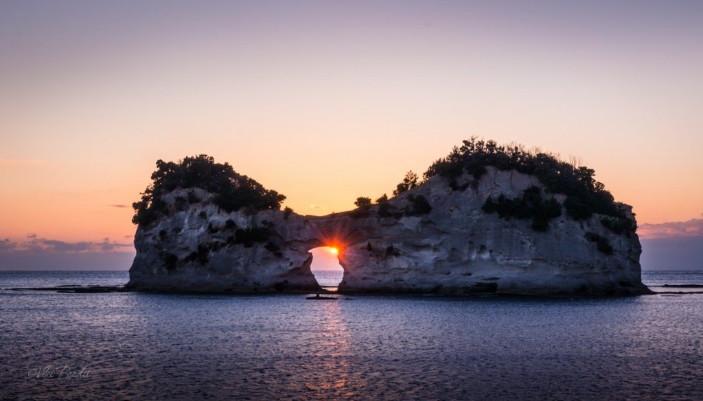
The rock island’s formal name is Takashima, but it is widely known as Engetsuto, which is literally translated to “round moon island”. This is due to the round-shaped arch in the center of the island. Along the coast there are several points where stairs lead down into the rock formations. It was still early so I walked past the sunset viewpoint towards the end of the coastline.

Engetsu Island is also a place of historical significance, as it was the site of a major battle between the Taira and Minamoto clans during the Genpei War in the 12th century.

On the way I passed an aquarium and a Glass boat ride. The rides on the glass boat are scheduled at hourly intervals. I had a free ticket to the glass boat from my all day pass but I was more in anticipation of seeing the thrilling sunset.

As I walked past the dock, I saw a cave at the edge of the coast. I had some 30 minutes on my clock so I went inside. It’s a small cave that opens up towards the sea.

I was thirsty after the long walk. After grabbing a Coke from a nearby vending machine, I started my walk back to the sunset viewpoint.

Sunset at Engetsu Island

The tide was low and the rocky banks were a perfect place to sit and gaze at this marvel of nature. I went down and sat at one of the boulders nearest to the sunset point. At times the tide goes so low that people can even walk to the island, but it is forbidden because the island is not very stable and sea urchins lying on the sea-bottom can cause injuries.

The island’s sandstone rocks have become less stable throughout the years The arch was artificially repaired in 2011 to make it earthquake-proof. I sat there for some time, lost in the stunning beauty amidst the sea.

As the sun slowly descended, I went up the stairs to the viewpoint. A small crowd had gathered, mostly locals. The sun was almost ready to show itself inside the hollow arch, so I quickly set up my gear and got ready for the iconic shot. Some thick clouds on the horizon did not allow the sun to stay for long.It came and went away so fast, but I got my shot!

This shot was taken handheld as a huge crowd had gathered to witness the amazing sun as it passed within the arch of Engetsu

After the sunset I walked back towards the beach. Buses are rare this side of the town and I hoped to have better luck getting one from near Shirahama beach. However on reaching the bus stop, I figured it was best if I walked back all the way to the station rather than wait half an hour for the next bus to come along.

Because I walked to most of the places, I didn’t use the bus pass to its full extent. The train arrived on time and I was on my way back home.

Engetsu Island is a unique blend of natural beauty and human history. The island’s unique shape, picturesque scenery and the lighthouse are some of the main attractions that draw visitors to the island. The island is also a popular spot for photography, with its beautiful landscapes, sunsets and sunrises. A day trip from Osaka to Wakayama can be easily done and if you start early you can visit all the three interesting spots that I was able to cover. After the day tour, the sunset at Engetsu is like a cherry topping. If you are in Shirahama, it a must visit place. An all day bus pass costs 1100 Yen. It covers all the major attractions in Shirahama including the thrilling Sandanbeki cliffs.

Thanks for reading. Please do leave me a comment if you liked the post follow my story as I come back to Wakayama in a couple of days to visit the magnificent Nachi Falls.

The majestic Heijo Palace

While I was living in Nara, Kyoto used to be one of my favourite places to hang out during the weekends. Unless I had a JR Pass lying around, I would generally take the Kintetsu local line from Nara to Kyoto. On-route, the train line passes through a wide stretch of paddy fields with a beautiful building standing majestically at the Heijo Palace site.

As the local train used to run past the heritage building, it used to captivate me each time, especially during my late-evening rides. Today I took out some time to explore the Palace grounds and capture its majestic persona, which at one point of time, used to be graced by the presence of emperors.

To understand the importance of Heijo Palace site, we need to go all the way back to the Nara Period (710-794 CE). It is said that the Japanese empire was born from Yamato Imperial dynasty, towards the end of the 7th century which also coincided with the end of the Asuka period. Before the last of the emperors of the Yamato kindom – Emperor Monmu passed away, he expressed his will to have his mother succeed him till his son would be mature enough to assume the imperial position.

One of the first actions taken by the Empress Genmei, was relocating the capital to Nara, which provided an auspicious location surrounded by mountains on three sides. In those times this region was known as Heijo-kyo. Empress Genmei, during her reign between 707 through 715 CE, established this region as her capital and commissioned many new Buddhist temples as well as moving and rebuilding older ones. Except for a five-year period (740–745), when the capital was briefly moved after the death of the emperor, it remained the capital of Japanese civilization until Emperor Kanmu established a new capital in Nagaoka-kyō in 784.

How to reach Heijo Palace Grounds

Because we stayed near Kintetsu Nara Station, we took the Nara Kotsu bus #12 from the nearby bus stand to Saki-cho bus stop. The ride takes about 20 minutes and the bus will drop you just beside the Daigoku-den Hall near the Heijo Palace Site Museum. As an alternative route, you can catch the Kintetsu-Nara local and get down at Yamato-Saidaiji. From there it is a 12 minute walk to the Heijo Palace site.

The bus route involves less walking and you can buy an all day bus pass that costs ¥500, if you are planning for an all day outing around Nara.

Origins of Heijo Palace

Heijo-kyo became the site of the Imperial capital when it moved from Fujiwara near Asuka in 710, thus establishing the Nara Period of Japanese history. It is said that the capital was designed on the model of the Chinese city of Chang’an, present-day Xi’an.

In its heydays, Heijo Palace site covered an area of about about one square kilometer. The site used to have on its premises the emperor’s residence as well as numerous government offices. For its great historical and cultural importance, the excavated remains of the palace, and the surrounding area, were established as a UNESCO World Heritage Site in 1998.

Although the palace site once stood as the majestic center of the ancient capital, all of its original buildings were eventually lost, with the exception of a single hall that was moved in the 8th century and now stands at Toshodai-ji Temple.

When the capital was moved away from Heijo-kyo in 784, Heijo Palace site and its adjoining government buildings were abandoned as officials and other citizens flocked to the new capital. The temples on the outskirts of the former capital, however, retained their importance, and the city of Nara eventually resumed its growth around these temples, while the palace grounds and its surrounding areas were reduced to paddy fields and waste grasslands.

As the bus dropped us off, we found ourselves in rural atmosphere. There were hardly any houses for as far the eye could see. Far away from the hum-dum of Nara park, the Heijo Palace site, sits quietly, rarely frequented by the hoards of tourists that flock to Nara.

The government however has gone to considerable lengths to showcase the history of Heijo Palace for visitors with historical reconstructions and museums. We decided to explore the museum first, gain some extra insight before going on to the ruins of the site itself. One of the first things you will notice inside the museum is excavations of a burial ground.

The Nara National Research Institute for Cultural Properties has conducted research and investigation of the site on a continual basis since 1959. Some other artifacts from the original palace building have been secured here like this shaft from the well inside the Imperial domicile area.

Here we see excavated remains of the roof tiles of the buildings surrounding the palace. Traditional Japanese roof tiles, Kawara are a highly visible and elaborate component of Japanese architecture. They display a technical and artistic sophistication while being highly functional.

Tiles of terracotta and clay were introduced to Japan in the sixth century and became popular immediately. These strong tiles could be easily made using locally sourced and readily available clay, they were fireproof and naturally water resistant, an important consideration in a country with heavy snow and rainfall.

In addition, the hall exhibits miniature models of the Imperial Palace and government offices from the Nara period. If you observe closely, these models used roofs instead of tiles. Such roofs were known as Warabuki. In this process, dried straw is tied into bundles which are then tied to the roof structure, with upper bundles overlapping the lower ones. The Warabuki roofs provided good protection from the snow and rain, but they were also susceptible to catching fire quite easily.

In the image below you can see an artists representation of how the Palace grounds used to look at the time when Nara was the capital of Japan. In the center of Heijo-kyo, there used to exist a 74-meters wide Suzakuoji Street extended straight from Rajomon Gate, the south gate to the capital. The western and eastern area of this street was respectively called Ukyo and Sakyo.

The planning of the capital was based on the Jobo system to layout the streets in a grid-like pattern. It is said that more than 100,000 people lived in Heijo-kyo during this period. Exploring the exhibits at the museum will take you about an hour.

As we came out into the bright daylight outside the museum, there are just ruins stretching far and wide. These are the base of the columns of the Latter Audience Hall. It was built on the orders of the Emperor Shomu after the capital moved back to Nara from Shigaraki in 745 CE. All that remains now of the Latter Imperial Audience Hall are the excavated foundations of the hall and the nearby ruins. 

From here we walked down to the Daigoku-den. Three major structures of the former palace complex have been reconstructed in recent decades. Foremost among them is the Former Audience Hall (Daigoku-den) which was recreated during the 1300th anniversary of Nara becoming Japan’s capital in 2010.

The emperor and empress lived, worked and received visitors in the imperial domicile section. It was surrounded by a roofed walkway, divided lengthwise by an earthen wall.  The building is called the “former” audience hall, because it was replaced by the “latter” audience hall in the second half of the Nara Period.

The large audience hall was used as the site of important ceremonies and meetings. Its ceiling is decorated by the four animals of the direction on the compass and the twelve animals of the lunar calendar. A throne stands in the center of the hall. The building is called the “former” audience hall, because it was replaced by the “latter” audience hall in the second half of the Nara Period. The latter audience hall’s foundations are visible to the east of the former audience hall.

The reconstruction was started in 2001 and completed in 2010. For the reconstruction, Japanese cypress wood was used. The building’s pillars and beams were painted in vermilion, the walls in white, the roof with ceramic tiles. The upper part of the interior of the hall was painted with symbols of the Chinese zodiac such as the Tiger, the Horse and the Ox alongside the walls, and floral pattern on the ceiling. The paintings were executed by the renowned painter Atsushi Uemura based on designs from the Nara period.

Inside the Daigoku-den hall, you can find many replicas created using historic documents left behind by people from the same period. This is a replica of the Shibi ( 鴟尾 ) that used to adorn the palace. A shibi is a Japanese ornamental tile set on both ends of the ridgepole that tops a shingled roof of Japanese castles and other important structures.

Here you can see the ornament that used to adorn the center part of the roof between the two Shibis.

In the center of the audience hall you can find a replica of the emperor’s throne, called Takamikura (高御座). This was an important item that symbolised the imperial office, and at state events such as the enthronement and New Year’s Day ceremonies the emperor proceeded to the audience hall and took his seat on the throne. Nobles lined up in the inner court south of the hall and paid their respect.

With no records of the construction or design of the Takamikura of the Nara period, the details are unknown. The reconstructed model of the Takamikura was made after experts consulted various literature and historical materials, and based on the throne in the Kyoto Imperial Palace which dates to the Taishō era. Details of the design and patterns were created by referring to materials such as the treasure of the Shōsōin repository.

After exploring the audience hall, we walked down tords the next compelling structure on the premises – Suzakumon Gate

The Suzakumon Gate

The placement followed the ancient Chinese palace model requirements at the time, where Suzaku (朱雀 Suzaku), the Vermilion Bird was the Guardian of the South. Research for the restoration of Suzakumon Gate started with excavations at the former site in 1964, and the production of a one-to-ten scale miniature model in 1965. In 1993, it was decided that the gate of Nara would be reconstructed.

In front of the Suzaku Gate, ceremonies were conducted on New Year’s Day and for welcoming or farewelling foreign envoys. In addition, ancient men and women exchanged their love songs there, calling it utagaki. The magnificent gate has an air of dignity as the front gate of the Palace.

It proved extremely difficult to work out what Suzakumon had looked like, as there were no surviving structural remnants. A conjectural model was developed, based on comparable architecture elsewhere, and the new gate was constructed from a mixture of traditional building materials (cypress wood and tiles) and concrete, in order to resist earthquakes. The reconstructed gate was opened in 1998.

As per old records, various ceremonies were conducted on New Year’s Day and other important occasions in front of the Suzaku Gate. In addition, men and women in those times exchanged their love songs here, during the celebration of <em>utagaki</em>. Villagers would sing and dance along with reciting of poetry, in celebration of the beginning of spring or autumn.

Many of the songs and poems, as well as accounts of the ritual itself, are recorded in the Man’yōshū and other contemporary documents, making them among the oldest forms of literature in Japan. These traditions, albeit in a modern way, have still been kept alive and if you find yourself in Nara around August, you must visit the site.

Suzakumon Gate was protected by guards and was usually closed. Its magnificent appearance as the main gate to the palace exhibited the authority of the government inside and outside.. The magnificent gate certainly has an air of dignity befitting the front gate of the Palace.

In front of the Suzakumon Gate lies a statue of Tanada Kajuro. At first I thought it was the statue of one of the emperors but you will be surprised that he was a local gardener who worked dedicatedly for protection of the heritage site.

After the capital was transferred from Nara to Nagaokakyo, various attempts were made to return the capital to Heijokyo, but as time passed, the ancient capital was in ruins as nature slowly took back the city.

Around the end of the Edo period, Kitaura Sadamasa started research on the site of Heijokyo. Then, at end of the Meiji Period, research by Sekino Tadashi and Kida Sadakichi revealed the appearance of the ancient capital of Nara. In between the Meiji and Taisho period, local people including Tanada Kajuro along with Mizobe Bunshiro launched a movement to preserve the former site of Daigoku-den.

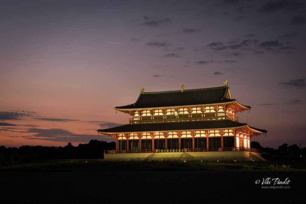
If you are willing to stay the evening you can capture some breathtaking shots of the palace. As light falls, the palace is illuminated. It appears as if any moment, we will be transported to the times when the Emperor would address his subjects during ceremonies.

As light falls, the palace is illuminated. The Former Imperial Audience Hall (Daigokuden) at the northern end of the palace was the largest and most important building in the complex. Here the Emperor had his throne and addressed his subjects on New Year’s Day just as the present Japanese emperor still does on January 2nd.

Thanks for reading! I look forward to your comments and questions. If you are looking to explore more of the Mie region, follow my story as I visit the married rocks of Futami

Opening Hours

9:00 to 16:30 (Last Admission 16:00)

Closed Days

Every Monday (If Monday is a national holiday, on Tuesday)
31st December
1st January

Admission Fee

Free

Gokarna Beach Trek

[su_progress_bar style=”thin” percent=”30″ text=”Difficulty Level – Easy” bar_color=”#ed97db” fill_color=”#cb0e6b” text_color=”#000000″]

This weekend I head out on a trek on the rocky cliffs along the coastline of Gokarna.

Gokarna is located along the Arabian Sea at the ear-shaped confluence of two rivers, the Gangavali and Aghanashini, around 580 km from Bangalore. Four of the most gorgeous beaches are located to the south of Gokarna. Our trek route was to start from the southern-most Paradise Beach and hike our way northwards towards Half Moon Beach, Om Beach, Kuddle Beach and finally end at Gokarna Beach.

Gokarna means Cow’s ear. There is an interesting piece of story behind how this place got this name. Legend has it that after a vigorous penance by Ravana, Shiva was pleased and offered three boons to him. For one of his wishes, Ravana asked for the Atma-Linga. Shiva took out the Atma-Linga from his own heart and gave it to Ravana with strict instructions that it should not be placed on ground until it was reached its final destination.

The Devas, fearing that Ravana would become all-powerful asked for help from Vishnu to somehow stop him. On the way, carrying the Atma-Linga towards Lanka, Ganesha met him in the garb of a cowherd. Vishnu and Ganesh played a trick on him and saw to that he kept the Linga on the Ground. When Ravana tried to pull it out, the shape of the Linga took a form of the Cow’s ears.

Gokarna is also an important center of Sanskrit learning. The early settlements of this region can be traced back to the Brahmins. It is also the residence of Bhandikeri Math and Togu Math where Sanskrit knowledge has been passed down from generations in Brahmin families.

Ride from Bangalore

My scheduled pick-up was at 7 p.m at Silk Board. Due to heavy Bangalore traffic I was delayed and finally made it at 7.45 p.m. I joined Ishan, Preethi, Srinivasan and Pradyumna at the Silk Board bus stop. Unfortunately Ishan wasn’t going on this trek and Salwat was already out there in Gokarna, so Preethi was our trek lead for the trip. Once there, I got to know that our pick-up Tempo was even more delayed. We introduced ourselves as we waited for the bus to arrive. It finally reached us at around 8:30 p.m.

After picking up the rest, we finally started for Gokarna at around 9:30 p.m. Along the way we stopped at a dhaba for dinner. I had a plate of Idli, the safest food around these parts. For the rest of the journey, I didn’t get much sleep on the bus. At around 8 a.m. in the morning, we stopped at an eatery at Shivamogga for breakfast. The Idli was warm and tasty. It also felt good to stretch the legs. After around an hour we passed through the Shettihalli Wildlife Sanctuary. I was lucky to spot a few peacocks along the way. As we neared the coast, the jackets were off as it grew more and more warmer.

Gokarna

It was noon by the time we reached our destination. The sun was beating down upon us. Salwat, sweating profusely, was waiting for us at the bus depot on Temple Road. We walked towards our home stay which by the way was not very far from the bus stop. At first impression, Gokarna might strike as a laid back town, growing up, trying to find its place in the modern world, but in all actuality it is really old, with a history that stretches back to a mention in the Bhagwad Gita.

For most of the time, it has been a village of fishermen and farmers with the only attraction being a temple, believed to contain Atma-Linga, the soul of Shiva. But Karnataka has entered a period of rapid change in tourism, and Gokarna is being dragged along with it.

Paradise Beach

After quickly freshening up and donning our beachwear’s, we drove by bus to a spot near the Paradise Beach Huts. From here we started the trek along the Paradise Beach trail towards Paradise Beach. The walk took us through a bushy forest along an elevated path. After walking for 15 minutes we started to descend. While going down we were presented with the stunning view of the beach. Cameras were out in a flash and why not. It is a paradise for beach lovers.

We climbed down the rocky hill towards the inviting beach. On the left I noticed a hippie trying to cook up a meal. By the looks of it, it was apparent he had been squatting there for days. The beach is in the shape of a small bay, curved inwards. Once on level land, the guys just ran off, flinging their stuff in the sand and tore towards the big waves.

Salwat informed us not go above waist level in the water. Well, he quickly had to change his advice as the incoming waves were already chest high. I found a secluded spot and took a few long exposure photographs of the beach. Unlike some other beaches I have been, here the rocks are sharp and I got a few bruises on my palms while climbing to finding a good spot.

We stayed at the Paradise Beach for over an hour. Once everyone had their fill of the waves, we started hiking towards the Half Moon Beach.

Half-Moon Beach

The trail to Half Moon Beach is a bit tricky with lots or rocks. On the way we passed Hells Cliff. Well not many can claim to be in “Paradise” and “Hell” on the same day 😉 On Hell’s Beach, there is a small rock. Some of the guys took up the climbing challenge.

Past the rocky terrain we reached a cluster of shacks. It was 4.30 p.m. and we were hungry as hell. We decided to have our lunch in one of the 3 eateries. I was surprised to see Israeli specialties on the menu. Not a die-hard fan of experimentation, I still went ahead and ordered the “Laffa” along with 3 of my friends. The food took time coming but it was tasty. It was like a huge Egg Roll with salads and boiled eggs. I was full just with that. They also have hammocks around which give a hippy feel to the area. I saw very few Indians on both Paradise and Half Moon Beach. They appear to attract mainly foreigners.

After relaxing for some time, we moved on to the Half Moon Beach. The harsh sun had given way to some nice pleasant breeze as we entered Half Moon Beach. The beach was devoid of tourists and I got some lovely photos in the golden hour. We didn’t spend much time here as we wanted to witness the sunset from a good vantage point.

Om Beach

We all were very excited at the prospect of viewing the sunset and we hurried along towards the Rock of Peace. “Rock of Peace” is a huge cliff towering over the side of Om Beach which extends deep into the Ocean. The view from here is fantastic. Om Beach is named so because it is shaped like the auspicious ॐ [Om] symbol. One can easily make out the Om sign from this cliff. The stage was set, but without any clouds the drama was missing. Some hippies had gathered here with drums. The slow beating of drums added to the serene moment.


It was difficult to move away even after the sun had set, but Salwat wanted us to reach the beach before dark, since the trail led through a forested area and it would become more and more difficult to find the trail in the darkness. So we got up and were on our way to the Om Beach. Down at the beach, light was fading fast. I wanted to get a good shot of the Parvati Rocks but it wasn’t to be. Om Beach is beautiful beach that seems to go on forever, surrounded by palm trees.  I have to come here again, to get a shot of the setting sun with the Parvati rocks in the foreground. I believe it will look gorgeous.

I lay on the beach staring at the stars for a long time, alone. I have started to understand that I do not share the same enjoyment from nature as others. Chattering disturbs me. I would just like to be a rock and stare at the wonder of nature.

Kuddle Beach Trek

After some relaxation on the Om Beach we headed out to Kuddle Beach around dinner time. I wasn’t too pleased as we arrived at the Kuddle Beach. Its dirty, full of restaurants and cafe’s. Cows are moving around. Litter is everywhere. Overcrowding, construction of lodges and other activities has definitely had an impact on this beach. There are also some lodges with rooms for as little as ₹1500. Salwat recommended the Kuddle Palace restaurant for dinner. In the restaurant, the guy taking our order appeared to be a Nepali. On asking, he confessed to coming here during season time to work for 4 months. Once the season ends, he heads back to his homeland in Sikkim.

Inside the restaurant, we were like this huge gang. All the tables in the restaurant were moved and joined together to form one big table. It was like a feast from one of those Asterix comics. I was missing the tasty Tibetan dishes I had in Sikkim, so I ordered a Thupka. After dinner I took a walk along the beach, below the stars. Some couples were also wandering along the beach. I was missing Mani, so I called her up. We talked for a long time. Relatively a long time for us would be 6 hours, but this time it was 40 mins. Eventually once everyone was done, we cleared the bill and walked towards the Gokarna Beach.

Gokarna Beach Trek

At the end of the Kuddle Beach, we had to climb up a row of stairs to head towards the Gokarna Beach. After the stairs, we reached an open field. Thankfully there were white markers guiding us along the trail or we would easily have gotten lost. On the way we gathered some dry branches and grass for the bonfire. At the end of the field we passed a Shiva Temple. It was a moonless night and we could barely make it out in the pitch darkness. Right after the temple a series of steps brought us to the edge of the Gokarna Beach.

Gokarna Beach was way cleaner than Kuddle Beach. No shacks or lodgings.  Boats were lined on the coast, belonging to fishermen who now probably earn more ferrying passengers along the coast. The beach was full of crabs. In every direction I could see holes create by crabs. We had a quick bonfire and then headed back to home stay. On the way back some of us we were already discussing to come back in the morning for sunrise.

We reached the home-stay at around 12:30 a.m. I activated the alarm for 4:30 a.m. and went to sleep straight-away at 1 o’clock.

Sunrise on the Gokarna Beach

I got up before the alarm could wake me up. I would like to believe I posses a biological clock that wakes me when I am truly serious about it. Even in Sikkim, I was up daily at around 4 a.m daily. In contrast, in Bangalore, I am rarely up before 10 a.m 😉 It was a pleasant surprise to find almost everyone already up and ready for the sunrise trek at 4:30 a.m. Salwat was tired and so we, in all 13 of us including me, headed out ourselves. The roads were lit but the beach area was pitch dark. We went following the same path we had come down the night before. The bonfire we had lit last night was totally doused by the waves. I was surprised that the tides had come all the way up to this point during the night. We hiked towards the Shiva Temple and took a detour from there towards the peak of that hill.

The Sun rose from behind the bushy forest at around 6:30. We took some clicks and then walked back towards the beach.

As we walked back towards our home-stay in proper daylight for the first time, I could see the endless blue sea with coconut and palm trees lining the beach. Already many had gathered to take a dip in the sea before going into the temple. I understand, Gokarna Beach is frequented more by Indian pilgrims than the random tourist. We walked across the quaint little town, through the streets lined with temples, eateries and traditional tile-roofed brick houses. The presence of beaches and temples together create a contrasting town. On one side we see the over-eager pilgrims and on the other we see the laid back hippies.

Ride Back to Bangalore

After a quick breakfast at Pai’s Restaurant we were on our way back to Bangalore. Deepali, whose hometown is not very far from here treated us to a sweet milk beverage. The day was hot. On the bus, I took a small nap since I had barely slept the last two days. On the way back Salwat offered a stop at the Jog Falls as a bonus. The waterfall was a whimper from what I had seen in the pictures. One should see this place roar in the monsoons. While admiring the falls I was lucky to spot a beautiful rainbow forming at the base of the falls. We also took our lunch there in a nearby restaurant. The menu was limited nor was the food any good.

Rest of the way I choose to sit upfront beside the driver, just looking at the road and the trees go by. Pradyumna was also there with his Kindle, reading. We talked a lot about the places he wants to visit. I gave him a few tips on Hampi. He is a silent type of guy. We stopped at an eatery around 4 in the evening. They had something new, I have never had before, Pepper fries. I also had a cup of coffee before getting back on the bus. Bangalore was still 120 km away. Since it was getting dark, I went back to my seat at the back. The guys started a game of antarakshi. It was fun and kept us entertained all the way to Bangalore.

It was midnight by the time we reached Bangalore. One of the guys Abhishek, shared a cab with me as his place was along the way. I was back in the cozy comfort of my home in half an hour. It is one of my fetishes, every place I visit, I need to get one amazing shot, that summarizes the place. Unfortunately I didn’t get one this time and this is going to haunt me until I go back again and get it.

[su_tabs]
[su_tab title=”Faqs”] [su_accordion]
[su_spoiler title=”Best place to stay in Gokarna”] Hotel Gokarna International (0832-257843 / 08386-256622/ 848) is one of the better lodges on the Kuddle Beach. Note there is another Hotel with same name in the town, so double-check[/su_spoiler]
[su_spoiler title=”Good restaurants in Gokarna?”] Kuddle Palace has good multi-cuisine food and also very cheap. On the Half Moon Beach you can find some shacks. The food is all right, but it takes a long time coming.[/su_spoiler]
[/su_accordion][/su_tab]

[su_tab title=”Places to see in Gokarna”] Along with the amazing beaches, Gokarna is also famous historically.

  1. Visit the Adi Gokarna & Aatma Linga Mahabaleshwara Temple.
  2. Hike to Yana natural rock formations, a couple of hours away
  3. Jogg Falls is 2 hours drive from Gokarna
  4. Dandeli Wildlife Sanctuary is a 6 hour drive from Gokarna. Tours are available through the reserve where you can, if you are lucky, check out the Black Panther, Bison & Iguanas.

[/su_tabs]