Train to Fujinomiya
Shiraito Falls with bridge
Closer view of Shiraito Falls
Raibow at the base of Shiraito Falls
Thanks for reading!
Today I went back to Wakayama to explore Nachisan and capture the iconic view of Sanjudo Pagoda in front of the Nachi Falls or Nachi-no-taki as it is known locally. After the exploits of my first outing on my own to Shirahama, I was much more confident today. Shirahama was an amazing experience with the thrilling Sandanbeki Cliffs, the lovely Shirahama Beach, and the most stunning sunset at Engetsu.
Nachi Falls ([那智の滝) in Nachikatsuura, Wakayama is one of the best-known waterfalls in Japan. It is said to be the highest single-drop waterfall in the country at 133 m. The mountain is also popular for Kumano Nachi Taisha, Seiganto-ji Temple, Sanjudo Pagoda, and the Hiryu-jinja Shrine all of which can be found in the vicinity of the waterfall.
I used the same approach as the day before while visiting Shirahama. I started a bit earlier at about 6 am. Since Nachi is further away, I wanted to have some cushion so I would have more time on hand to roam around the temple grounds.
I reached JR Nara Station at about 6.30 am and caught the next available train to Tennoji. From Tennoji I took the 7.79 am Kuroshio Limited Express, bound for Kii-Katsuura Station. If you are traveling from Osaka, you can catch the same train from JR Osaka Station.
The Kuroshio Limited Express is the fastest way to reach Nachi from Osaka
The train was mostly empty. I found myself a window seat. If you have the option, choose the window seats on the right. The view is amazing as the train travels along the pacific coast for the better part of the ride. The interiors of the train are luxurious and the big clear windows make for a lovely experience for those who love to watch the scenery as the train goes.
The Kuroshio Express passes through some beautiful countryside. After crossing the Wakayama Station, the train line moves almost parallel to the coast, going past rocky cliffs along the blue sea. The cliffs near Kushimoto Station, located on the southern tip of the Kii Peninsula are especially interesting – shaped like a natural bridge going into the ocean.
After a long ride of three and a half hours, I reached Kii Katsuura Station at 11.33 am. It is one of those quaint little stations you see in the rural areas of Japan.
The tourist information booth is located inside the station premises. The lady at the counter provided me a printed map. She was pleasantly surprised when she came to know that I was from India as not many foreigners come all the way down there.
She plotted out for me a “Nachisan Excursion Course”. The course would start from Daimon Zaka Slope and go up to Nachi Falls, via the Kumano Grand Shrine, Nachisan Seiganto-ji Temple, and the Sanjudo Pagoda. She also informed me that it would take me about 2 hours to complete the hike to Nachi Falls. Once she had provided me all the information, she directed me towards the bus stop nearby from where I was supposed to catch the bus to Nachi Falls.
Outside the station, I found a vending machine serving hot french fries amongst other fast food items. I wasn’t sure if I would find a proper eatery on the Nachi mountain, so I got one for myself and put it in my backpack for later.
There are a number of restaurants and shops near the station. The shops were mostly empty at this time of the day, with very few people around. The next bus to Nachi Falls was scheduled for 12.30 pm, so I wandered around the area looking for some souvenirs.
A small group had gathered near the bus stop by the scheduled time. Most of them were Japanese couples. I didn’t notice any foreigners among them. This bus also makes a stop at Nachi Station too, in case you are arriving via Mie.
As the bus drove through the town, one can see many abandoned broken-down buildings in the area. The typhoon Talas that struck in 2011 had been quite severe on the town of Nachikatsuura. Once the bus moved into the outskirts of the city and entered the mountains, it was a much more serene view.
It takes about 20 minutes to reach Daimon Zaka Bus stop from the Kii Katsuura Station. The ride costs me ¥420. A young couple also got down with me. The bus continued on with the rest of the tourists to Nachisan.
I could have gone directly to Nachi-san but I wanted to hike through the primeval forest. What is the fun of coming to this beautiful countryside if one doesn’t experience the unique landscape of Kumano’s spiritual forest?
Daimon-zaka means “large gate” referring to a gate that once stood at the entrance to the slope. I was not really sure which way to go, so I followed a narrow path going towards high ground, hoping it was the right trail.
The path leads up to two huge cedar trees, standing on either side, which serves as a beginning to the Daimon-zaka Slope. These two almost 800-year-old cedar trees are known as Meoto Sugi (Married Couple) Trees. For centuries these trees have been standing together welcoming pilgrims and tourists – making their way up the hill. In 2000, the locals came together and performed a wedding ceremony between them. It is believed that couples marrying between these trees will find eternal love.
Beyond the married cedar trees, the path gives way to an ancient cobblestone staircase called Kumano Kodo trail which runs from the base of the valley all the way to the parking lot near Nachi San.
The Kumano Kodo (Ancient road of Kumano) is a network of pilgrimage roads that link all three major sacred sites in the Kii Mountain range. Japan’s Kumano Kodo trail is one of only two pilgrimages in the world with UNESCO World Heritage status – the other being Spain’s Camino de Santiago. During the Heian period, people used to make the pilgrimage from Kyoto to Kumano Taisha using this trail. The trail, however, is not limited to Nachi. Its total length is about 300 km extending across the prefectures of Wakayama, Nara, and Mie. In July 2004, the Kumano Kodo, pilgrimage routes were registered as UNESCO World Heritage as part of the “Sacred Sites and Pilgrimage Routes in the Kii Mountain Range“
A fleet of rocky steps took me up the Daimon Zaka slope. The massive cedar trees surrounding the trail create a divine atmosphere in the primeval forest. The Kumano Kodo’s rugged, forested mountains, quiet rural valleys, rivers, and waterfalls provide a spectacular backdrop for hikers.
At a point in the trail, the forest opens up beside the road. From the road, though very far away, I could see the top of Sanjudo Pagoda.
The trail is properly maintained and easy to climb. Mani, my wife, was here in December when it had rained profusely and the slopes were a bit slippery. So, fellas, keep an eye out for the weather before you embark on this hike.
I reached the parking lot in about half an hour and about 270 steps. The hike is not very tough and I saw several aged Japanese making their way down, as I was hiking up the hill.
Once I came out of the Daimon Zaka slope, there is a series of long steep stairs to get to Kumano Nachi Grand Shrine. Kumano Nachi Taisha (熊野那智大社) is a Shinto shrine and part of the UNESCO-designated World Heritage Sacred Sites and Pilgrimage Routes in the Kii Mountain Range. Its main deity is Izanami no Mikoto, who is a deity of unity. Along these stairs, you can find numerous shops selling black stone souvenirs.
Climbing up, I reached a fork on the stairs. The left one with a big red Torii led to Kumano Nachi Taisha. I decided to skip the Shrine for now and if time permitted return back to see it.
To the right, just at the fork in the stairs, one can find a small wooden temple with a statue of Kanzeon Bosatsu, merciful hermaphrodite Goddess (観世音菩薩) is one of the five great Bodhisattva who administers mercy and compassion. A stone pillar in front says “For World Peace.“
Kanzeon (観世音) can be broken down into three words – the one who constantly surveys (kan 観) the world (ze 世) listening for the sounds (on 音) of suffering. Kanzeon and Kannon is used in Japanese with the same meaning. You might think why these sound almost similar. Well… Kanzeon was shortened by removing the ze(世) to make it Kannon.
A few paces later, I found myself in front of the Seiganto-ji Temple. I lit some incense sticks at the altar. Seiganto-ji is the first temple that is visited in the Saikoku 33 Kannon Pilgrimage. It is said that Seiganto-ji was established by an Indian monk, Ragyo-shonin, who happened to travel to the Nachisan area and practiced ascetic Buddhism at the base of Nachi Falls in the 4th century. As such, the original build of the Seiganto-ji qualifies to be the oldest temple in the Kumano area.
The original buildings were destroyed during the Japan unification war. What we see currently was re-built in 1590 AD on the orders of Hideyoshi Toyotomi (who was the Military General and a friend of Oda Nobunaga). Seiganto-ji was designated as a World Heritage Site in 2004. The main worshiped deity here is Kanzeon Bosatsu (also known as Bodhisattva Kannon).
From the temple grounds, on the other side, one can get a full view of the Kii mountain range. I didn’t spend too much time in this area – given my rush to capture the iconic Sanjudo Pagoda in front of Nachi Falls.
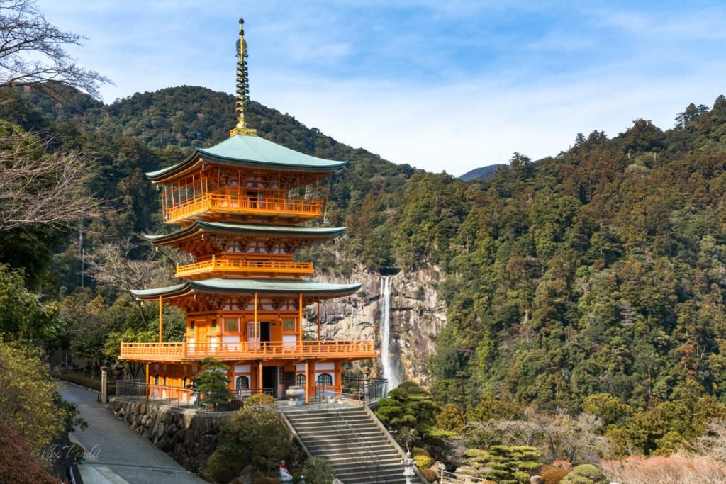
After walking down a fleet of stairs I finally found myself in front of the vermilion pagoda juxtaposed with the cliff-diving Nachi Waterfall. It is hard to explain in words the majestic view of the waterfall in the backdrop, with the vermilion pagoda standing against it. I can only imagine how this view might have influenced the spirituality of the residents in the temples and shrines here. This is definitely the most beautiful photo of Nachi Falls that I have captured.
Since ancient times people have considered this area to be a pilgrimage. For centuries people have visited these lands believing in the mystic powers of the mountains of Kumano. One of these beliefs is that if a worshiper prays at the Three Grand Shrines, he or she can attain salvation. The shrines thus attract many pilgrims ranging from members of the Japanese Imperial Family to the common folks.
I took a few more photos of the stunning pagoda with the Nachi-no-taki together. If you have time do not miss going up to the top balcony of the Pagoda.
The hike had made me hungry. I dug into the french fries I had obtained from the vending machine at the Kii-Katsuura station. I was also carrying a couple of shrimp Onigiri with me. After the quick lunch, I just laid down on one of the seats in front of the pagoda, mesmerized by the amazing view.
It was 2.30 pm already. After the quick rest, I walked downhill along the road towards Nachi Falls. A few meters downhill there is a narrow stone path cutting through the forest, towards the Nachi Falls.
One can also take the road if you don’t want to cut through the forested trail.
After walking for about 15 minutes I was at the gates of Hirou Shrine, one of the three Kumano Grand Shrines. It was also a relief to see the bus stop just nearby.
Hirou Shrine’s gate marks the entrance to the Nachi Falls. I went through the Torii to a wide stone stairway that goes directly to the base of the waterfall. The cedar trees are much more massive here than anywhere on the trail.
At the base, I took a breather in front of the cascading waterfall. Flowing between the peaks of the Kumano Nachi mountain, the Nachi River creates over 48 waterfalls. Nachi Falls, also known as Nachi-no-taki, is the largest of them.
If one wants a closer look at the waterfall, one can enter the shrine and take the stairs up towards a wooden deck. It costs ¥200 to enter the shrine. From the vermilion deck, you can get the best view of Nachi falls as the water falls from the incredible height, hits the rocks below, and transforms into a small stream at the foot of the waterfall.
While coming down there is a small reservoir with natural spring flowing through the mouth of a stone-carved dragon head. Drinking spring water is supposed to give one good health. I filled my bottle with some to take back home for my wife.
It gets dark early in these mountains. It was only 4 pm but the light had begun to fade. I went back to the bus stand and waited anxiously for the next bus to show up. Anxious, because the last train to Osaka was at 6.10 pm and I didn’t want to miss it. Missing that last train would have left me stranded in Nachi. Thankfully, the Japanese are very punctual and the bus arrived exactly at 4.25 pm and I reached Kii Katsuura station by 4.50 pm.
Waiting at the platform it was hard not to be still lost in those memorable moments that I spent at the stunning Nachi Falls. I had a wonderful time in the mountains of Nachi. Though the pilgrimage has been in operation since ancient times, it still remains quite off the map for most tourists. That inadvertently resulted in a richer experience for people like me who love silence. If you are planning a day trip to Nachi Falls, I would advise visitors to stay back for a night in Nachi so you can start the tour early in the morning. I missed out on exploring the Kumano Nachi Taisha because of lack of time.
Nachi is a journey into the realm of nature that brings purification to the soul. For centuries Japanese pilgrims have walked the Kumano Kodo, a more than 1,200-year-old network of trails that pass cedar forests, cascading waterfalls, and picturesque villages in the Kii Mountains.
Nachi being the terminal station, the train pulled into the station about 20 minutes early. I got myself a bag of peanuts and took my seat on the train. It was a near 4-hour journey back to Tennoji. The hike had taken a toll on me. I turned on my music playlist thinking of the charming elevated temple with the lovely view of Nachi Falls. I spent nearly 8 hours traveling for that one memory of the magnificent vermillion three-story pagoda and I will tell you that it was worth it.
Stretching across the Kii Peninsula on the island of Honshu, the pilgrimage takes us off the beaten track into a world of stunning scenery, soothing hot springs, delicious food. This journey through southern Wakayama and the Kumano Kodo will prove to be one of the most exceptional experiences you will have during your trip.
Thanks for reading. Leave me a comment if you liked the post or follow my story as I visit the illuminated Kenrokuen Garden in Kanazawa.
The Kumano Kodo is a mountain trek with waterfalls and shrines and physically demanding. Set mostly in the deep forest, there are a number of steep ascents and descents along the trail. I would highly recommend walking poles.
I only covered a fraction of the Kumano Kodo trail. For the full route, please allow 7 days in total, including rest days.
Most of the areas I visited were free. To enter the shrine at the base of Nachi Falls it cost ¥200 per person.
Provided below are the bus time tables between Kii Katsura Station and Nachi Falls. Please note Nachi Falls is not the terminal stop. There another stop that goes all the way up to Nachisan mountain.
Updated March 17th 2018
Timings & fares are subject to change
Bus fare from Kii Katsura Station (Adult / One Way)
Daimonzaka: ¥420
Nachisan / Nachi-no-Taki-mae( Falls): ¥620
I have been to Nara Park several times. The ever popular Tôdai-ji temple and Kasuga-Taisha shrine are always crawling with inquisitive tourists, but today Mani & I wander beyond these cultural landscapes into the Kasugayama Primeval Forest. The natural environment of Kasugayama is an integral yet invisible part of the shrines and temples in Nara Park. The park is so large you could easily wander into the Primeval Forest, without even knowing it.
Kasugayama Primeval Forest is a primeval forest spread over 250 hectares, near the summit of Kasugayama. It contains around 270 different kinds of trees. Hunting and logging have been prohibited in the sacred forest since 841 CE. As a result, the forest backdrop of the shrines that you see today have remained unchanged since the Nara period, retaining the authenticity in spirit and feeling from yesteryear.
I had been looking forward to hike to Uguisuno-taki Falls for some time now, but the wet weather in Nara kept preventing me. Eventually the rains gave way this week and we took the opportunity to hike up the Wakakusa mountain. After a quick meal at the college cafeteria, Mani & I walked towards Todaiji from where the trail starts.
The hike to the Falls is about 10 km round trip, from the base of Wakakusayama. You can find the trail somewhere between Todai-ji and Kasuga Taisha which leads into the woods. A signboard is present at the start of the trail, so it won’t be tough to find.
None of the busybee tourists flock this trail. It was only after maybe half an hour that we we came upon a group of cheerful elderly ladies, trudging back towards the city. They greeted us with smiles and “Konnichiwa.” I always find the friendliest of people on hikes. Maybe its the mountain air or the excitement from conquering the hike.
There are some Snake warning signs along the path so be careful.
Deep into the forest, we found some lovely looking Japanese beautyberry shrubs. It is a deciduous shrub, most notable for producing purple berries during fall. These fruits are not toxic but also not edible for humans. They serve as al alternative food to the birds and deer in the forest.
Halfway up the mountain the woods become thicker and the trees become taller. With the thick forest of pine trees surrounding me, I felt like a tiny little ant. There was silence all around us except for the sudden chirping of the birds. It was a welcome break from the increasing number of temples I had been visiting of late. The inside of the forest is dim even in the daytime as sunlight is not able to penetrate through the tall trees.
The waterfall lies at the northeastern end of the Kasugayama primeval forest. The fall does not lie along the main trail so you will have to follow the directions provided along the way. There are proper signs that will tell you once you have reached the exit point to get to the waterfall. From there you have to descend down from the main trail. The path becomes very narrow here and at some curves, are a bit tricky to negotiate in the wet mud. After about 15 minutes of descent, we reached the waterfall at around 2:30 pm.
Mobile internet services might be intermittent at several points of the trail
Uguisuno-taki Falls has been a popular local spot since the Edo period (1600-1868). It takes its name from the popular Uguisu bird, also known as the Japanese bush warbler. The Uguisu, with its camouflaged colors, is more often heard than seen. Its distinctive breeding call can be heard throughout most of Japan from the start of spring. Since the Edo Period, the Japanese have anticipated the first calls of the bush warbler as it heralds the coming of spring in Japan.
We spent some time at the base of the falls, capturing some photos of the surrounding area. It is not a grand waterfall. It would be about 8 meters in height and due to the season, the water was a little more of a trickle. However what is interesting is that the water flow never dries up here. Still it was a nice place to sit down and relax. The water at the base of the fall was very very cold.
By 3:30 pm we started our walk back. The way back was much faster. We were quickly out of the wooded area where the skies were much more visible. In the late afternoon, the Sun had sprayed the forest with a golden glow.
Once you are out of the woods, it feels quite pleasant walking on the pebbled path. Surprisingly I didn’t notice any deer in the area, though this isn’t very far from the Nara Park where they can be found loitering in abundance.
After walking for about an hour, we were back at Nara Park in front of the glowing, brown Wakakusayama, slated to be burned in a couple of weeks as part of the Yamayaki festival. Every winter on the fourth Saturday of January, Wakakusayama’s slopes are burned during the spectacular Wakakusa Yamayaki festival.
I love to be able to experience wilderness areas in peace.The Uguisuno-taki Falls is not a very big waterfall, but the hike alone is gratifying in itself. It is the only waterfall in the vicinity of Mt Kasuga. The trail to Uguisuno-taki continues beyond the waterfall and I hope we can come back another day to continue on that path and see where it goes.
Thank you for reading. Please leave me a comment or ask away if you need any information for hiking to the hidden waterfall.